11 Best Hikes in Canyonlands National Park
Eleven Canyonlands hikes across Island in the Sky, The Needles, and Horseshoe Canyon, with reviewed maps, profiles, road notes, and live closures.
Canyonlands is divided by the Green and Colorado rivers. A trail that looks close on a park map may be hours from another by road, and the three routes into this guide's more remote corners demand very different vehicles and preparation.
These eleven hikes are arranged by the kind of trip they require, not by an app's popularity score. Mesa Arch, Grand View Point, and White Rim Overlook are straightforward Island in the Sky walks. Gooseberry, Lathrop, and Alcove Spring drop below the rim. Confluence Overlook belongs to The Needles, Horseshoe Canyon sits far to the west, and Gooseneck Overlook requires travel on the White Rim Road.
As of August 2026, Island in the Sky Scenic Drive and the main Needles road are open. Grand View Point Trail closes from 6 a.m. Monday through 4 p.m. Thursday until October 1 for construction. White Rim Road is open to high-clearance four-wheel-drive vehicles with low range, subject to rapid changes after rain. Check the park's live road and construction notices on the morning of travel.
What changes a hiking day here
Choose one district for the day
Island in the Sky, The Needles, and Horseshoe Canyon do not connect by internal paved roads. Put the trailhead into the route plan before booking lodging or setting a start time. A long hike after a two-hour dirt-road approach is a different day from a walk off the scenic drive.
Carry desert quantities of water
NPS advises two to three liters per person for front-country walks and four liters or more for backcountry routes. Island in the Sky has no campground water. From April through September, plan strenuous hiking outside the 10 a.m. to 4 p.m. heat window.
Read cairns, but carry a map
Cairns mark many routes, yet long trails cross slickrock and washes where the next marker can be hard to see. Carry a topographic map, a light, first aid supplies, and an offline route. Wet sandstone loses traction; thunder means it is time to leave exposed rims and ridges.
Leave pets outside the hiking plan
Pets are prohibited on all hiking trails, at overlooks, off trail, and in the backcountry, even when carried. The narrow exception for certain road travel does not apply to the hikes in this guide.
| Trail | Distance | Time | Difficulty | Best for |
|---|---|---|---|---|
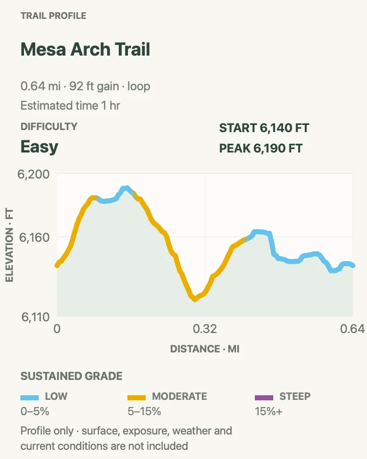
| Mesa Arch Trail | 0.6-mile loop | 1 hr | Easy | A short first walk and a dramatic window over canyon country |
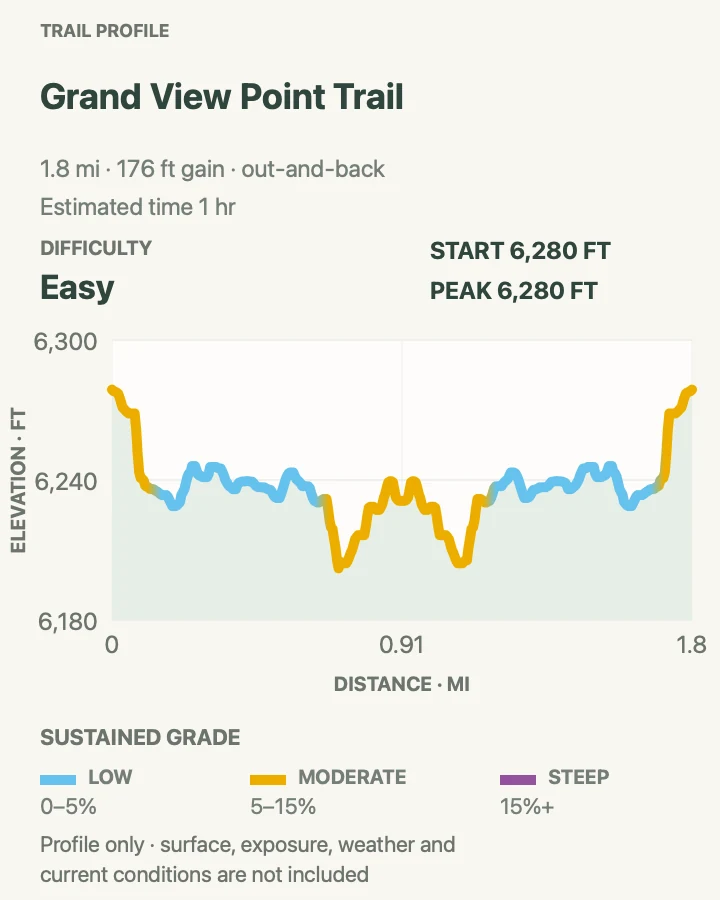
| Grand View Point Trail | 1.9 miles out and back | 1 hr | Easy | A rim walk with continuous views into both river systems |
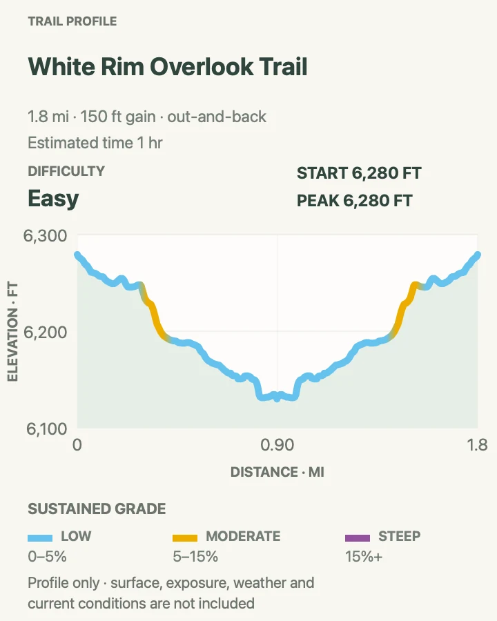
| White Rim Overlook Trail | 1.8 miles out and back | 1 hr | Easy | A quieter mesa-top view of Monument Basin and the Colorado River corridor |
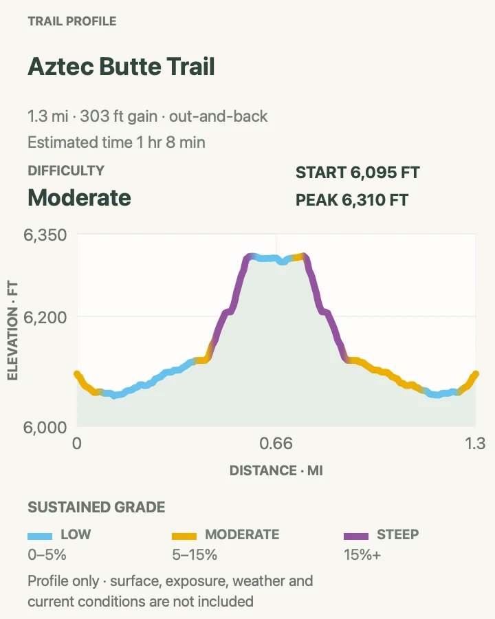
| Aztec Butte Trail | 1.3 miles out and back | 1 hr 8 min | Moderate | Short scrambling and respectful views of ancestral structures |
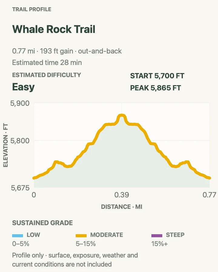
| Whale Rock Trail | 0.8 miles out and back | 28 min | Easy | A playful slickrock climb with a quick viewpoint |
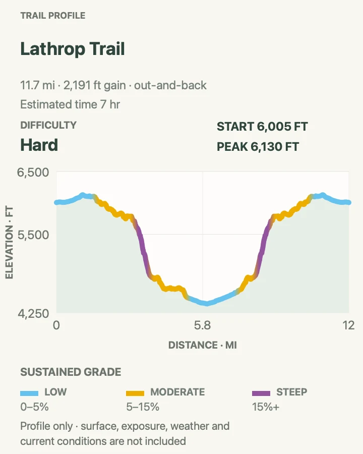
| Lathrop Trail to White Rim Road | About 12 miles out and back | 7 hr | Hard | A full-day descent from mesa grassland to the White Rim bench |
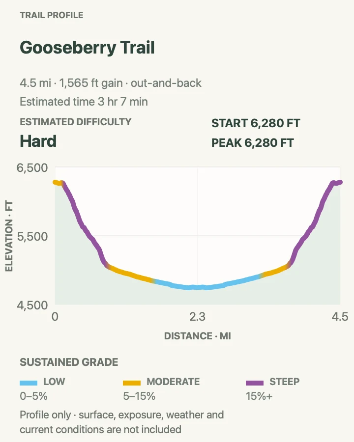
| Gooseberry Canyon Trail | 4.7 miles out and back | 3 hr 7 min | Hard | The park's steepest maintained Island in the Sky descent |
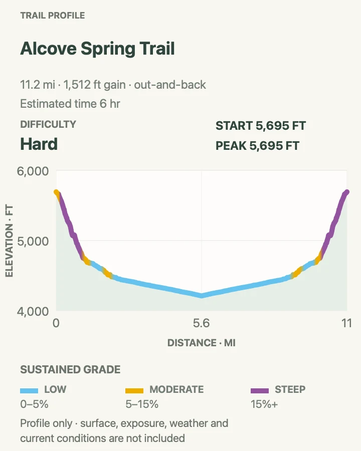
| Alcove Spring Trail | 11.5 miles out and back | 6 hr | Hard | A remote canyon descent beneath Moses and Zeus |
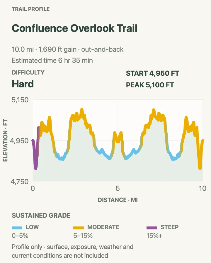
| Confluence Overlook Trail | About 10.1 miles out and back | 6 hr 35 min | Hard | Seeing the Green and Colorado rivers meet from 1,000 feet above |
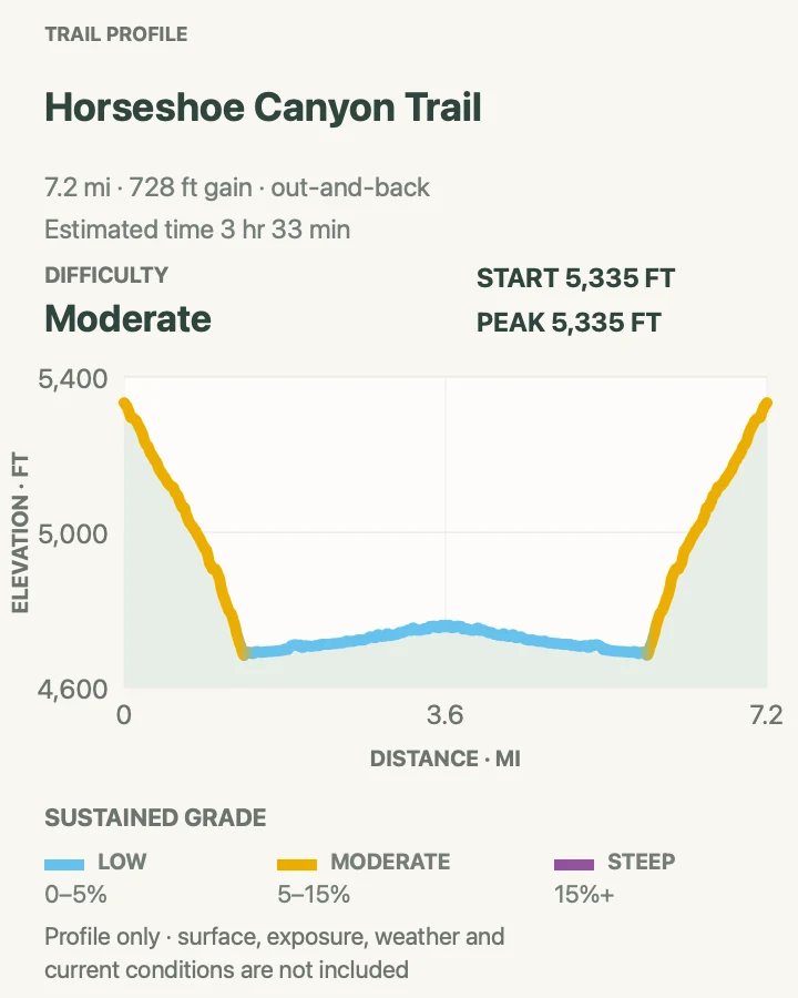
| Horseshoe Canyon to the Great Gallery | About 7.3 miles out and back | 3 hr 33 min | Moderate | A remote canyon walk to extraordinary ancestral rock imagery |
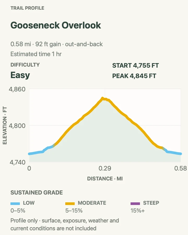
| Gooseneck Overlook | 0.6 miles out and back | 1 hr | Easy | A short walk to a remote bend of the Colorado River |
Mesa Arch Trail
- Distance
- 0.6-mile loop
- Elevation gain
- 90 feet
- Time
- 1 hr
- Difficulty
- Easy
- Route type
- loop
- Parking
- Use the signed Mesa Arch lot on Island in the Sky Scenic Drive; arrive well before sunrise or wait until the first crowd leaves.
- Best time
- Early morning for the famous glow, or late afternoon for quieter cliff views.
- Pets
- Pets are prohibited on the trail and at the overlook.
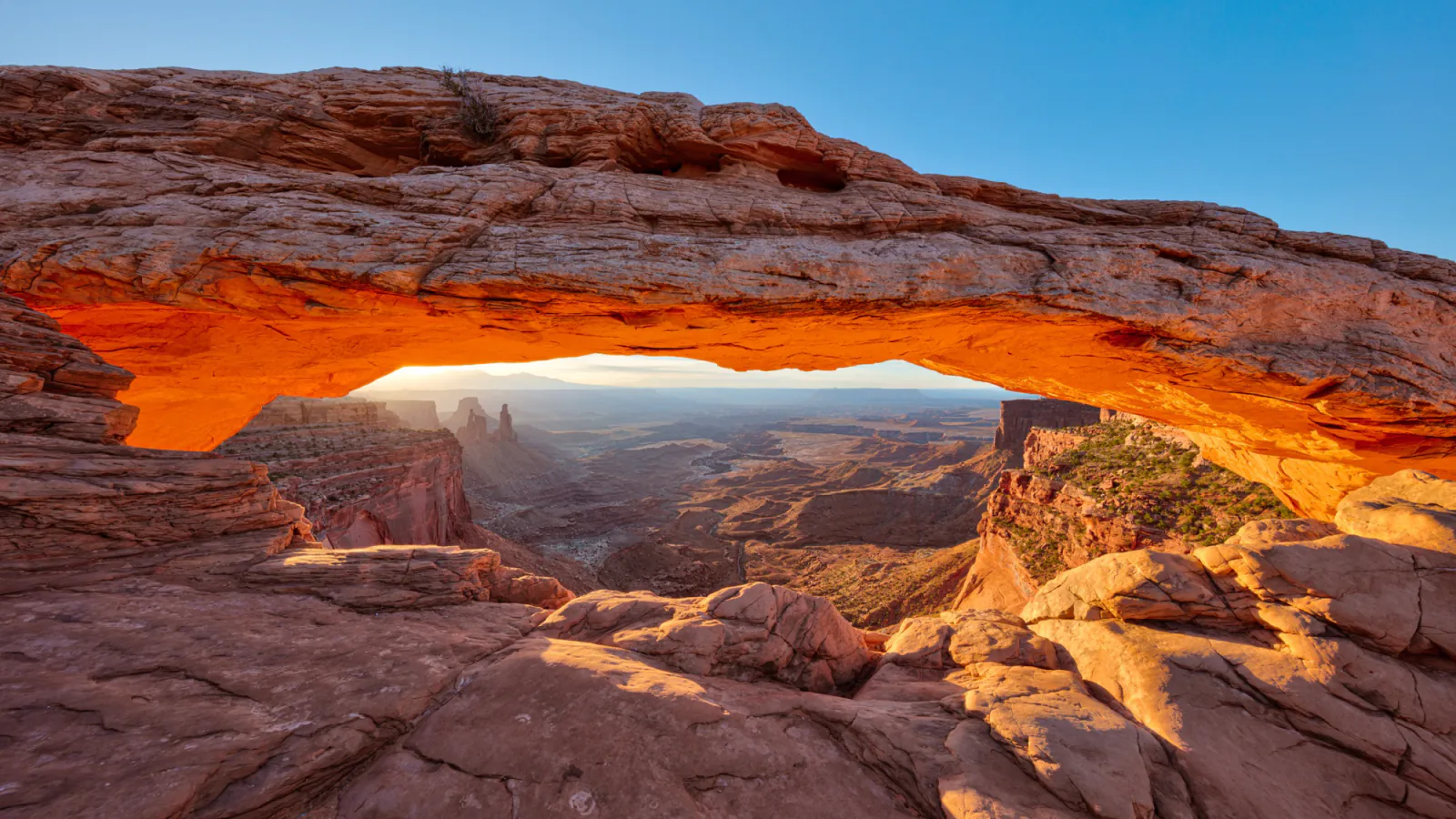
The loop crosses sandy slickrock to an arch perched at the mesa edge. Through the opening, Washer Woman, the White Rim, and the La Sal Mountains stack into a view that explains Island in the Sky better than any roadside pullout.
Sunrise is busy and the cliff below the arch is unguarded. Walk the loop counterclockwise if the first approach is congested, stay off the arch itself, and give photographers room without stepping onto fragile soil.
What helps on this route
- Bring a light for a pre-dawn start and inspect the path again on the walk back.
- Try a later visit if the lot is full; the arch remains impressive without sunrise light.
Terrain and access: Sand, low slickrock steps, cairned loop, exposed cliff edge, little shade, and a compact parking area.

Grand View Point Trail
- Distance
- 1.9 miles out and back
- Elevation gain
- 180 feet
- Time
- 1 hr
- Difficulty
- Easy
- Route type
- out-and-back
- Parking
- Drive to the end of Island in the Sky Scenic Drive only when the construction closure is not in effect.
- Best time
- Friday through Sunday before October 1, 2026; otherwise morning or late afternoon in cool weather.
- Pets
- Pets are prohibited on the trail and at Grand View Point.
Grand View follows the mesa rim from the developed overlook to a rocky point above Monument Basin. The modest profile masks frequent cliff exposure and uneven ledges, but the route never commits to a canyon descent.
Construction closes the overlook, trail, and final road segment from 6 a.m. Monday to 4 p.m. Thursday through October 1, 2026. No hikers may pass the closure. On open days, expect limited parking and turn around rather than parking along vegetation.
What helps on this route
- Confirm the weekday closure schedule before leaving Moab.
- Keep children close where the path narrows beside the rim.
Terrain and access: Uneven slickrock, short ledges, cairns, open mesa, unguarded rim, and minimal shade.

White Rim Overlook Trail
- Distance
- 1.8 miles out and back
- Elevation gain
- 150 feet
- Time
- 1 hr
- Difficulty
- Easy
- Route type
- out-and-back
- Parking
- Use the small signed pullout near the Gooseberry trailhead; do not invent a roadside space when it is full.
- Best time
- Late afternoon, when the east-facing overlook catches softer light.
- Pets
- Pets are prohibited on the trail and overlook.
A nearly level path crosses open slickrock and low desert plants to the eastern edge of Island in the Sky. The final bench looks over the White Rim Road, Monument Basin, and the La Sal Mountains without the long descent of nearby Gooseberry.
Parking is the limiting factor. If the pullout is full, continue to another trail and return later. The broad rock surface can make cairns disappear against the horizon, so look back at junctions.
What helps on this route
- Carry water despite the easy profile; the entire walk is exposed.
- Stay on rock or marked tread to protect biological soil crust.
Terrain and access: Level sandstone benches, sandy patches, cairns, low desert shrubs, cliff-edge overlook, and no shade.

Aztec Butte Trail
- Distance
- 1.3 miles out and back
- Elevation gain
- 300 feet
- Time
- 1 hr 8 min
- Difficulty
- Moderate
- Route type
- out-and-back
- Parking
- Use the Aztec Butte trailhead on the road toward Upheaval Dome.
- Best time
- A dry morning when slickrock is cool and free of ice.
- Pets
- Pets are prohibited on the trail.
The sandy approach divides below two buttes. The eastern branch climbs Aztec Butte for wide views; the western branch reaches the smaller butte and two ancestral Puebloan structures tucked below its rim. Both involve hands-on slickrock and exposed ledges.
The structures are protected places, not shelters or climbing objectives. View them from outside, touch nothing, and stay off walls. Turn around if wet rock, ice, or comfort with exposure makes the descent doubtful.
What helps on this route
- Save the route in advance because the fork creates two possible objectives.
- Descend the same rock line used on the climb; improvised shortcuts reach steeper slabs.
Terrain and access: Sandy wash, steep slickrock, ledges, light scrambling, exposed rim, protected archeological sites, and cairned branches.

Whale Rock Trail
- Distance
- 0.8 miles out and back
- Elevation gain
- 190 feet
- Time
- 28 min
- Difficulty
- Easy
- Route type
- out-and-back
- Parking
- Park at the Whale Rock pullout near Upheaval Dome and keep the travel lane clear.
- Best time
- A dry, low-wind morning or cool late afternoon.
- Pets
- Pets are prohibited on the trail.
Whale Rock climbs the back of a rounded sandstone dome. The route is short, but bare rock and steep drop-offs make it more serious than a flat nature walk. Cairns lead toward the high point and broad views over Island in the Sky.
Friction is excellent when the sandstone is dry and poor when it is wet, icy, or dusty. Stop below the crest if wind or exposure feels uncomfortable; the open views begin well before the top.
What helps on this route
- Wear shoes with reliable tread rather than smooth casual soles.
- Avoid the dome during thunderstorms because there is nowhere sheltered.
Terrain and access: Bare sandstone dome, short steep sections, cairns, exposed edges, wind, and no shade.

Lathrop Trail to White Rim Road
- Distance
- About 12 miles out and back
- Elevation gain
- 2,190 feet
- Time
- 7 hr
- Difficulty
- Hard
- Route type
- out-and-back
- Parking
- Use the Lathrop trailhead on Island in the Sky Scenic Drive and begin before the exposed grassland heats.
- Best time
- Cool spring or autumn weather with a stable forecast.
- Pets
- Pets are prohibited on the trail and in the backcountry.
Lathrop begins gently across open grassland, reaches a canyon-rim viewpoint at roughly five miles round trip, then drops through steep switchbacks to White Rim Road. The reviewed route continues to the road, losing about 1,600 feet before the return climb.
The rim viewpoint is a sensible shorter day. Hikers continuing below it need backcountry water, a light, and enough reserve for the ascent in late-day heat. Do not count on passing vehicles for water or a ride.
What helps on this route
- Decide at the rim whether the group has time and water for the full descent.
- Watch the sky; the upper grassland offers little shelter from lightning.
Terrain and access: Open mesa grassland, cairned slickrock, steep switchbacks, loose rock, White Rim bench, 1,600-foot descent, and scant shade.

Gooseberry Canyon Trail
- Distance
- 4.7 miles out and back
- Elevation gain
- 1,570 feet
- Time
- 3 hr 7 min
- Difficulty
- Hard
- Route type
- out-and-back
- Parking
- Use the Gooseberry trailhead near White Rim Overlook; spaces are limited.
- Best time
- A cool morning in spring or fall, avoiding wet rock and ice.
- Pets
- Pets are prohibited on the trail and below the rim.
Gooseberry drops about 1,400 feet in little more than two miles. Rough switchbacks cross cliffs and scree before reaching the White Rim bench, making the climb back the dominant part of the day.
Loose rock and exposure begin quickly. This is a poor choice for hot afternoons or anyone hoping that a short mileage figure means an easy outing. Turn around early if the descent is already consuming too much water or time.
What helps on this route
- Use poles only if they help on loose switchbacks without upsetting balance near edges.
- Keep at least half the water for the ascent.
Terrain and access: Very steep switchbacks, cliff bands, scree, loose rock, exposed White Rim bench, roughly 1,400 feet of climbing on return, and little shade.

Alcove Spring Trail
- Distance
- 11.5 miles out and back
- Elevation gain
- 1,510 feet
- Time
- 6 hr
- Difficulty
- Hard
- Route type
- out-and-back
- Parking
- Use the signed trailhead on the road toward Upheaval Dome and begin with a full day of water.
- Best time
- Cool spring or fall weather after checking for storm risk.
- Pets
- Pets are prohibited in the backcountry.
The trail drops about 1,300 feet past a large alcove, then follows a broad canyon toward the Moses and Zeus towers. The long return retraces sand, rock, and the final climb to the mesa.
The alcove provides a memorable waypoint but is not a safe thunderstorm shelter. Carry a topographic map and avoid entering the canyon when heavy rain could produce a flood. The towers are technical climbing formations; the hiking route remains below them.
What helps on this route
- Mark the base of the exit route before wandering farther along the canyon floor.
- Build turnaround time around the 1,300-foot climb, not the easier inward pace.
Terrain and access: Steep mesa descent, sandstone alcove, sandy canyon floor, cairns, tower views, long exposed return, and no dependable water.

Confluence Overlook Trail
- Distance
- About 10.1 miles out and back
- Elevation gain
- 1,690 feet
- Time
- 6 hr 35 min
- Difficulty
- Hard
- Route type
- out-and-back
- Parking
- Start from the Big Spring Canyon trailhead in The Needles, reached by the paved main park road.
- Best time
- A cool, clear day from autumn through spring.
- Pets
- Pets are prohibited on the trail and in The Needles backcountry.
Confluence Overlook crosses open country along the northern edge of the faulted Needles terrain. Short descents and climbs accumulate across the day before the trail ends at an unguarded cliff above the meeting of the Green and Colorado rivers.
The official distance is about eleven miles; the reviewed trace is slightly shorter. Use NPS trail signs and the district map as the authority in the field. Shade and water are scarce, and the endpoint remains fully exposed.
What helps on this route
- Allow time for repeated small climbs on the return rather than judging the day from net elevation alone.
- Stay well back from the final cliff, especially in gusty wind.
Terrain and access: Open desert benches, slickrock, sandy washes, repeated short climbs, cairns, sparse shade, and an unguarded 1,000-foot overlook.

Horseshoe Canyon to the Great Gallery
- Distance
- About 7.3 miles out and back
- Elevation gain
- 730 feet
- Time
- 3 hr 33 min
- Difficulty
- Moderate
- Route type
- out-and-back
- Parking
- Reach the west rim trailhead by 30 miles of dirt road from UT 24 or 47 miles from Green River; use a paper map and check road conditions first.
- Best time
- Spring or fall, starting early enough for the return climb before heat builds.
- Pets
- Pets are prohibited on the trail and below the rim.
An old four-wheel-drive road drops roughly 780 feet from the west rim, then the route follows sandy Horseshoe Canyon past cottonwoods and several rock-image panels to the Great Gallery. The climb out arrives at the end of the day.
NPS recommends a gallon of water per hiker and at least five hours for the walk. Summer trips are dangerous; finish before noon or begin after 4 p.m. with a light. Road conditions can shift from ordinary dirt to four-wheel-drive travel after rain or wind.
What helps on this route
- Do not use turn-by-turn GPS as the sole guide to the trailhead.
- Never touch, trace, wet, or lean against rock imagery.
Terrain and access: Steep rim road, sand, intermittent wash, cottonwood groves, uneven rock, remote dirt-road access, and a 780-foot climb at the finish.

Gooseneck Overlook
- Distance
- 0.6 miles out and back
- Elevation gain
- 90 feet
- Time
- 1 hr
- Difficulty
- Easy
- Route type
- out-and-back
- Parking
- The trail begins along White Rim Road, which requires a day-use permit for motorized or bicycle travel and a high-clearance four-wheel-drive vehicle with low range.
- Best time
- During a properly permitted White Rim trip in dry, stable conditions.
- Pets
- Pets are prohibited in the backcountry, including in vehicles on White Rim Road.
Gooseneck Overlook is a short path from White Rim Road to a cliff above a tight Colorado River bend. Salt movement has warped the exposed rock layers, adding geology to a view that few scenic-drive visitors reach.
This is not a quick detour from the paved mesa road. White Rim travel requires a permit, low-range four-wheel drive, self-rescue supplies, and current road information. The walk is easy only after the difficult approach has been handled correctly.
What helps on this route
- Include the stop in a White Rim itinerary rather than making it the sole reason for the drive.
- Keep vehicles on the established road and hikers back from the abrupt cliff.
Terrain and access: Short sandy and rocky path, remote White Rim bench, unguarded river overlook, no shade, and serious four-wheel-drive approach logistics.

Official planning sources
Trail access and safety details were checked against these National Park Service pages. The maps and profiles use the reviewed route geometry stored with this guide.
- NPS: Current alerts, traffic, and construction
- NPS: Road conditions by district
- NPS: Hiking routes by district
- NPS: Grand View Point construction schedule
- NPS: Horseshoe Canyon access and hiking
- NPS: Desert, flood, and lightning safety
- NPS: Pet rules
- NPS: Permits and reservations
- NPS: Island in the Sky trail table
- NPS: Needles trail table
Map data © OpenStreetMap contributors. Trail geometry and planning details include National Park Service public information.