12 Best Hikes in Glacier National Park
Twelve Glacier hikes across Lake McDonald, Logan Pass, St. Mary, Many Glacier, and Two Medicine, with maps, profiles, access notes, and live alerts.
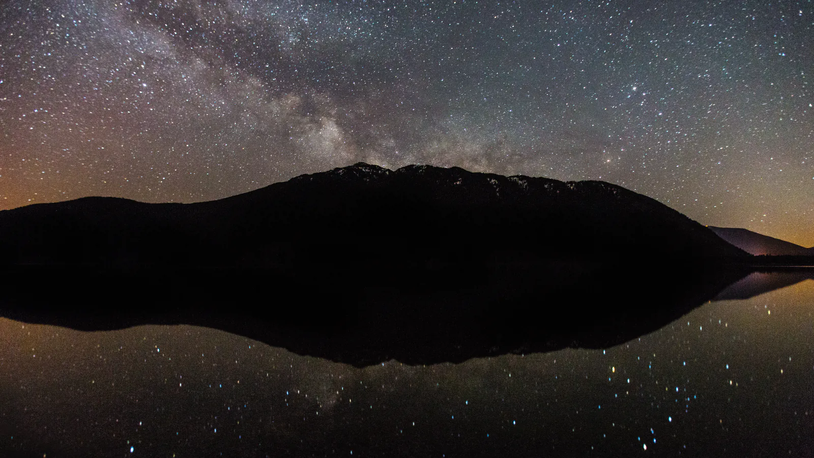
Glacier has more than 700 miles of trail, but trail choice begins with geography. A hike near Lake McDonald is not a quick substitute for one in Many Glacier, and a Logan Pass start depends on road access, parking, or a shuttle. These 12 outings are spread across the park so the list works as a trip-planning tool rather than a popularity chart.
Trail of the Cedars and Swiftcurrent Nature Trail cover the easy end. Siyeh Pass, Cracker Lake, and Scenic Point demand a full mountain day. Between them are lake, creek, waterfall, and overlook hikes that fit around the road corridor a traveler already has.
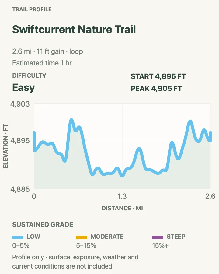
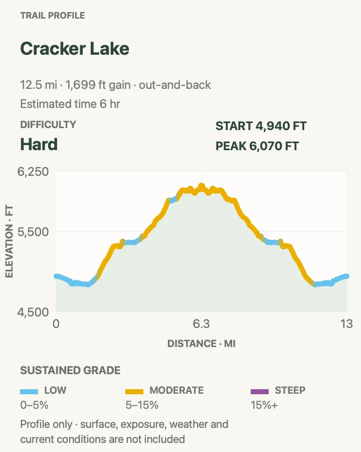
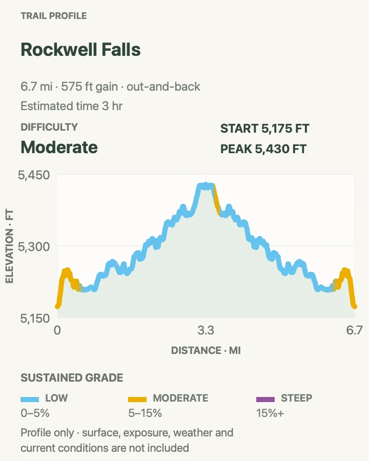
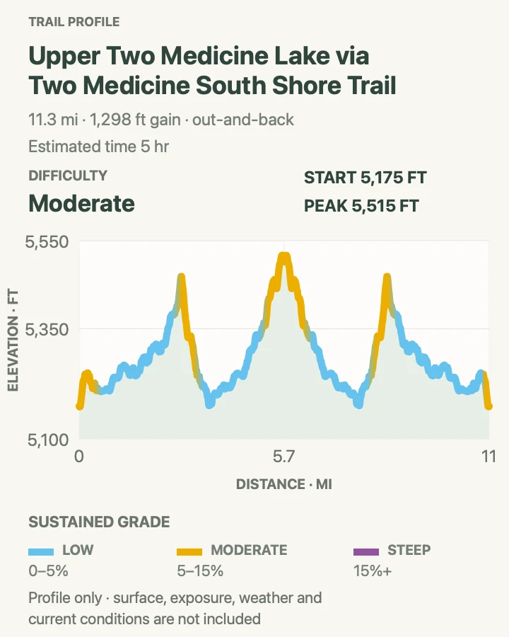
The route line behind each profile supplies the distance and gain shown here. Trail status can change because of snow, bridges, wildlife, fire, or maintenance. Read the live alert panel and the park's trail-status report again on the morning of the hike.
What changes a hiking day here
Road corridor first, hike second
Going-to-the-Sun Road, Many Glacier, Two Medicine, and the North Fork have separate travel patterns. In 2026, a vehicle reservation is not required for Going-to-the-Sun Road, while Logan Pass uses timed parking and a ticketed shuttle pilot. Rules and operating dates can change by season, so confirm the current transportation page before building a day around one trailhead.
Carry bear spray where you can reach it
Glacier is home to black bears and grizzly bears. Hike in a group when possible, make noise near streams and blind corners, keep food and scented items under control, and carry bear spray on your body rather than buried in a pack. The park requires 100 yards of distance from bears and wolves and 25 yards from other wildlife.
Snow and cold water outlast warm weather
High trails may hold steep snowfields after lower valleys feel like summer. Streams and lakes remain dangerously cold. Carry a rain shell and warm layer on every mountain hike, avoid swift fords, and do not climb onto slick rocks beside waterfalls. A dry parking lot does not describe conditions at a pass.
Offline maps are part of the kit
Cell coverage is limited outside Apgar and St. Mary. Save the right area map before driving, leave a trip plan with someone, and know the last shuttle time if the route depends on one. Point-to-point hikes need a transport plan that still works if the day runs long.
| Trail | Distance | Time | Difficulty | Best for |
|---|---|---|---|---|
| Rocky Point Trail | 2 mi | 1 hr | Easy | A short Lake McDonald shoreline hike |
| Upper McDonald Creek Trail | 5.6 mi | 2 hr 30 min | Easy | Creek views away from the busiest stops |
| Trail of the Cedars | 0.9 mi | 1 hr | Easy | An accessible old-growth forest loop |
| Avalanche Lake Trail | 6.1 mi | 3 hr | Moderate | A classic forest-to-mountain lake day |
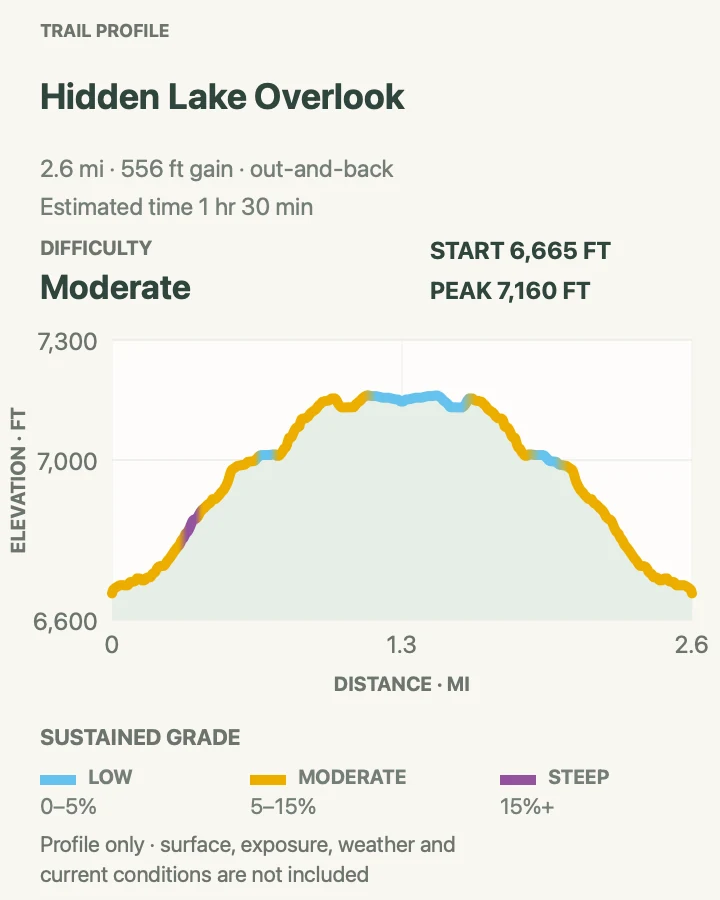
| Hidden Lake Overlook | 2.7 mi | 1 hr 30 min | Moderate | An alpine overlook from Logan Pass |
| Baring Falls Trail | 1.3 mi | 1 hr | Easy | A short waterfall stop near St. Mary Lake |
| Siyeh Pass Trail | 10.1 mi | 6 hr 30 min | Hard | A long point-to-point alpine crossing |
| Swiftcurrent Nature Trail | 2.6 mi | 1 hr | Easy | An easy Many Glacier lake loop |
| Cracker Lake Trail | 12.6 mi | 6 hr | Hard | A remote turquoise lake beneath Mount Siyeh |
| Rockwell Falls Trail | 6.7 mi | 3 hr | Moderate | A moderate Two Medicine waterfall hike |
| Upper Two Medicine Lake via South Shore Trail | 11.4 mi | 5 hr | Moderate | A full lake-to-lake day in Two Medicine |
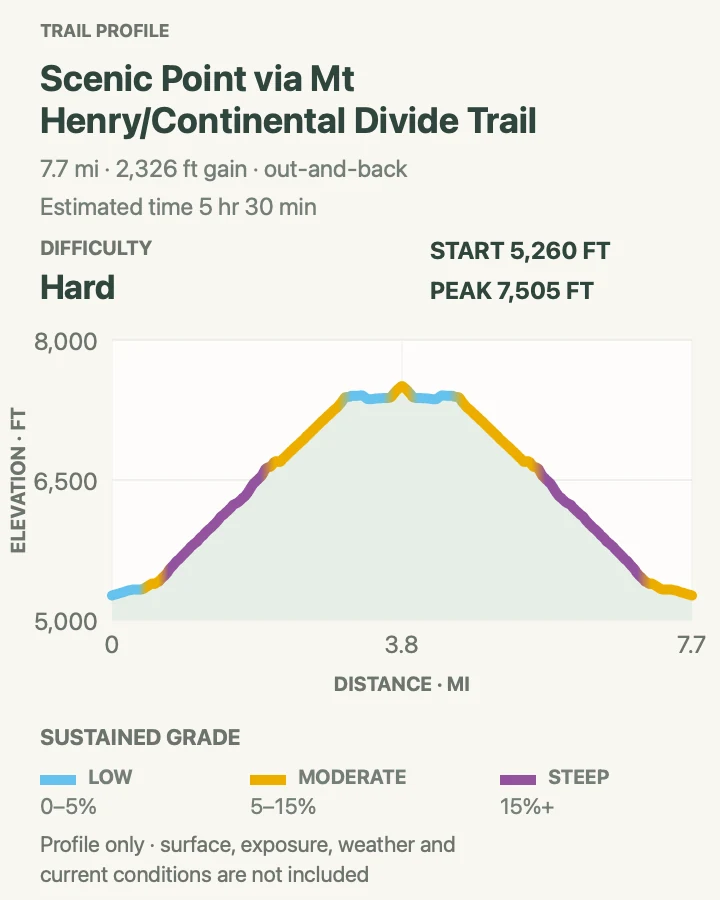
| Scenic Point Trail | 7.8 mi | 5 hr 30 min | Hard | A strenuous viewpoint above Two Medicine |
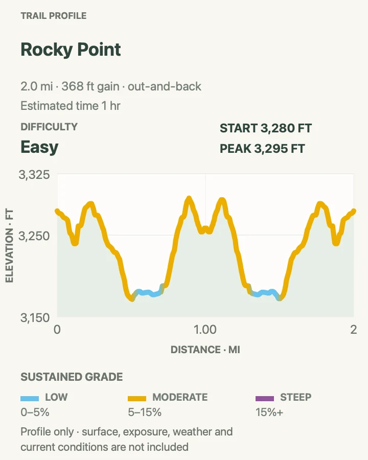
Rocky Point Trail
- Distance
- 2 mi
- Elevation gain
- 370 feet
- Time
- 1 hr
- Difficulty
- Easy
- Route type
- out-and-back
- Parking
- Use the Fish Creek Campground area and follow current signs for day-use parking.
- Best time
- Morning or evening for quieter forest and softer light across Lake McDonald.
- Pets
- Pets are not allowed on park trails. Trained service animals are allowed.
Rocky Point is a modest west-side walk with a big payoff at Lake McDonald. The trail leaves the Fish Creek area, moves through forest affected by earlier fire, and reaches open shoreline viewpoints across the lake toward the mountains.
The route is useful on an arrival day because it avoids the drive to Logan Pass and does not require a full alpine kit. Roots and uneven ground still make it a trail rather than a lakeside promenade. Watch for campsite and spur junctions on the return.
What helps on this route
- Keep bear spray accessible even on this short trail.
- Check Fish Creek parking and campground access before driving in.
Terrain and access: Forest tread, roots, short rolling grades, and rocky shoreline near the turnaround.

Upper McDonald Creek Trail
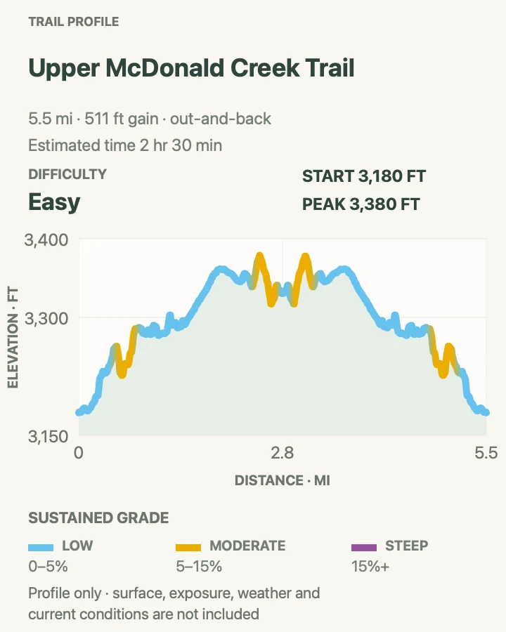
- Distance
- 5.6 mi
- Elevation gain
- 510 feet
- Time
- 2 hr 30 min
- Difficulty
- Easy
- Route type
- out-and-back
- Parking
- Park only in a legal pullout near the signed trail access along Going-to-the-Sun Road.
- Best time
- Late spring through fall when the road and creekside trail are open and free of hazardous snow.
- Pets
- Pets are not allowed on park trails. Trained service animals are allowed.
Upper McDonald Creek follows rushing water through cedar and hemlock forest, passing pools, boulders, and side views into the drainage. The grades stay mild, so the main question is how far to continue before retracing the route.
Creek noise can hide both wildlife and approaching hikers. Make your presence known at blind turns and stay off wet logs and rocks beside fast water. Several roadside access points can be confusing, so save the chosen start before leaving the vehicle.
What helps on this route
- Do not enter the creek when runoff is swift or water is cold.
- Use an offline map to distinguish the trail from short roadside paths.
Terrain and access: Mostly gentle forest trail with roots, rocks, damp sections, and unguarded creek edges.

Trail of the Cedars
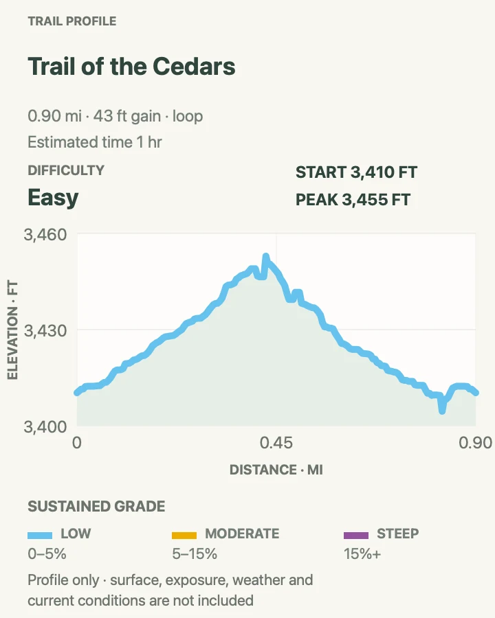
- Distance
- 0.9 mi
- Elevation gain
- 45 feet
- Time
- 1 hr
- Difficulty
- Easy
- Route type
- loop
- Parking
- Use Avalanche Creek parking or the seasonal Going-to-the-Sun Road shuttle stop.
- Best time
- Early morning or by shuttle after the parking area fills.
- Pets
- Pets are not allowed on park trails. Trained service animals are allowed.
Trail of the Cedars loops through a moist old-growth forest at Avalanche Creek. Boardwalk and paved sections pass western red cedar, black cottonwood, and interpretive signs before crossing the creek gorge.
This is one of the park's most accessible walks and also the approach to Avalanche Lake. Crowds cluster near the bridge and trail junction. Complete the loop in either direction, and allow longer than the mileage suggests if the group wants to read every sign.
What helps on this route
- Use the shuttle when the Avalanche area is full.
- Stay on the boardwalk around sensitive wet forest.
Terrain and access: Boardwalk and paved trail with gentle grades; accessible conditions can vary with construction or weather.

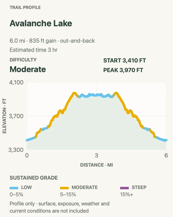
Avalanche Lake Trail
- Distance
- 6.1 mi
- Elevation gain
- 840 feet
- Time
- 3 hr
- Difficulty
- Moderate
- Route type
- out-and-back
- Parking
- Start from Avalanche Creek parking or arrive on the seasonal road shuttle.
- Best time
- An early start on a clear day before the trail and lake shore become busy.
- Pets
- Pets are not allowed on park trails. Trained service animals are allowed.
Avalanche Lake begins on Trail of the Cedars, then climbs beside Avalanche Creek through dense forest. The grade is steady rather than punishing. At the lake, narrow waterfalls drop from the cirque beneath Bearhat Mountain.
The first beach is often crowded, while a little extra walking along the shore can find breathing room. Keep food packed and never leave a daypack unattended. Wet roots and polished stones deserve care on the descent, especially after rain.
What helps on this route
- Add the Trail of the Cedars loop instead of rushing through it.
- Keep food secured at the lake even while taking photographs.
Terrain and access: Steady forest climb with roots, rocks, bridges, and a broad lake shore at the turnaround.


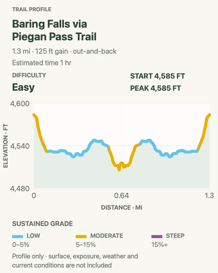
Baring Falls Trail
- Distance
- 1.3 mi
- Elevation gain
- 120 feet
- Time
- 1 hr
- Difficulty
- Easy
- Route type
- out-and-back
- Parking
- Use the Sunrift Gorge area or the nearest operating Going-to-the-Sun Road shuttle stop.
- Best time
- Morning or late afternoon when the short trail is quieter and road access is straightforward.
- Pets
- Pets are not allowed on park trails. Trained service animals are allowed.
Baring Falls drops over a dark rock ledge near the shore of St. Mary Lake. The short approach fits beside a road day, yet it still leaves the pavement for forest, creek, and lake views.
The rocks near the falls stay slick and the water is cold. Use the maintained viewing area rather than climbing beside the cascade. This outing can also be linked with longer shoreline paths when trail status and transport allow.
What helps on this route
- Keep children off wet rocks at the base of the falls.
- Check the shuttle stop and road-crossing arrangement before leaving the trailhead.
Terrain and access: Short forest trail with stairs, roots, creekside rocks, and wet surfaces near the falls.

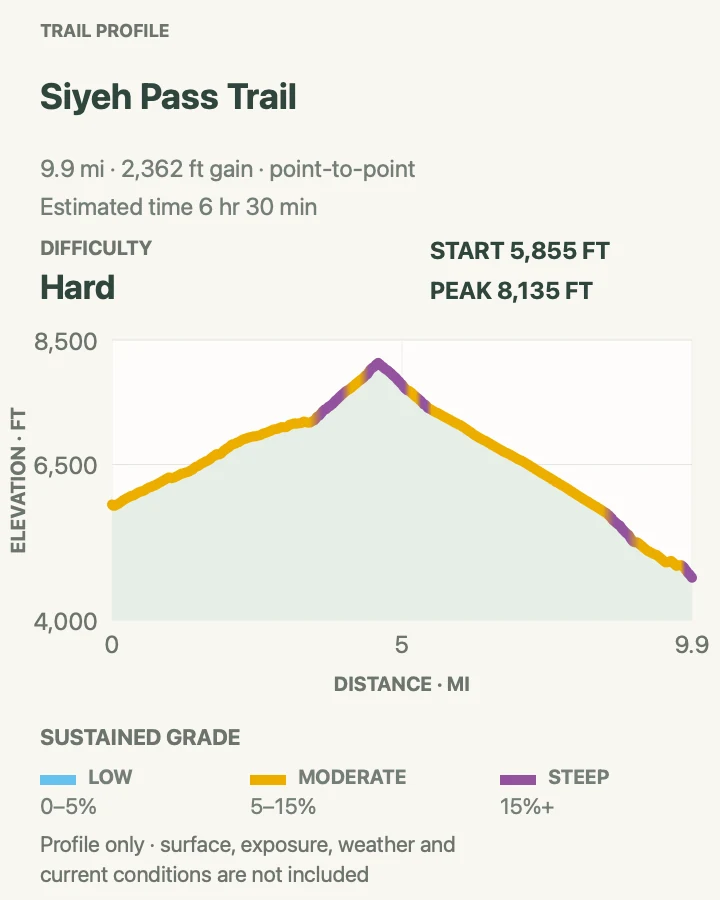
Siyeh Pass Trail
- Distance
- 10.1 mi
- Elevation gain
- 2,360 feet
- Time
- 6 hr 30 min
- Difficulty
- Hard
- Route type
- point-to-point
- Parking
- Use the Piegan Pass and Sunrift Gorge shuttle stops or arrange a legal point-to-point pickup.
- Best time
- A clear summer day after the pass is free of hazardous snow and before afternoon storms.
- Pets
- Pets are not allowed on park trails. Trained service animals are allowed.
Siyeh Pass crosses from forest into Preston Park, climbs beneath Mount Siyeh, and drops through a stark high basin toward Sunrift Gorge. The point-to-point layout keeps the scenery changing and makes transport part of the route.
The high traverse is exposed to wind, lightning, sun, and lingering snow. Confirm both trail and shuttle status before committing. Missing the final ride can turn a hard day into a transport problem, so start with a generous margin.
What helps on this route
- Record the final shuttle time and carry a backup transport plan.
- Turn around before lightning reaches the open pass.
Terrain and access: Long forest approach, alpine meadow, sustained pass climb, exposed traverse, and a lengthy descent.

Swiftcurrent Nature Trail
- Distance
- 2.6 mi
- Elevation gain
- 10 feet
- Time
- 1 hr
- Difficulty
- Easy
- Route type
- loop
- Parking
- Use designated Many Glacier parking near the Swiftcurrent Lake area.
- Best time
- Early morning for calm water, with extra awareness for bears in low light.
- Pets
- Pets are not allowed on park trails. Trained service animals are allowed.
Swiftcurrent Nature Trail circles the lake below the Many Glacier Hotel, mixing forest shade with open views of Grinnell Point and the surrounding peaks. Its gentle grade makes it a good Many Glacier introduction.
Dense vegetation and berry patches make bear awareness necessary despite the developed setting. Make noise, keep children close, and do not run if wildlife appears. Shoreline sections can be muddy after rain or high water.
What helps on this route
- Carry bear spray; hotel views do not remove bear habitat.
- Walk the lake in the direction that gives the group the best light and wind.
Terrain and access: Mostly gentle lakeshore and forest tread with roots, mud, and a few open developed sections.

Cracker Lake Trail
- Distance
- 12.6 mi
- Elevation gain
- 1,700 feet
- Time
- 6 hr
- Difficulty
- Hard
- Route type
- out-and-back
- Parking
- Start from the signed Cracker Lake trailhead in Many Glacier and follow current parking directions.
- Best time
- A long summer day with stable weather and an early departure.
- Pets
- Pets are not allowed on park trails. Trained service animals are allowed.
Cracker Lake is a long out-and-back to a pale blue lake beneath a high wall of Mount Siyeh. The route begins in the Many Glacier valley, passes horse traffic and forest, then opens into the upper basin.
Mud, dust, and horse use can slow the lower trail. The lake basin has little shelter from wind and weather. Carry layers even when the valley is warm, and leave enough time for the full return rather than treating the lake as the halfway point on the clock.
What helps on this route
- Step off on a durable edge when yielding to horses and follow the rider's instructions.
- Pack a warm layer for the exposed lake basin.
Terrain and access: Long mixed-use trail with forest, mud or dust, open basin travel, and sustained mileage.

Rockwell Falls Trail
- Distance
- 6.7 mi
- Elevation gain
- 570 feet
- Time
- 3 hr
- Difficulty
- Moderate
- Route type
- out-and-back
- Parking
- Use designated Two Medicine parking near the south-shore trail access.
- Best time
- Morning in summer or early fall, after checking bridge and trail status.
- Pets
- Pets are not allowed on park trails. Trained service animals are allowed.
Rockwell Falls follows the south side of Two Medicine Lake before turning into forest toward a two-part cascade. The route is longer than a roadside waterfall stop but less committing than the area's high passes.
Creek crossings, vegetation, and blind corners call for bear noise. Water levels can alter small crossings and make rocks near the falls slippery. The boat schedule may suggest other combinations, but this mapped version is a self-contained out-and-back.
What helps on this route
- Keep bear spray accessible along noisy creeks.
- Do not climb beside the falls for a closer angle.
Terrain and access: Lakeshore and forest trail with rolling grades, roots, bridges, and wet rock near the cascade.

Upper Two Medicine Lake via South Shore Trail
- Distance
- 11.4 mi
- Elevation gain
- 1,300 feet
- Time
- 5 hr
- Difficulty
- Moderate
- Route type
- out-and-back
- Parking
- Begin at the Two Medicine area; verify road, parking, and seasonal boat operations.
- Best time
- A long summer day with a steady forecast and an early start.
- Pets
- Pets are not allowed on park trails. Trained service animals are allowed.
The South Shore Trail links Two Medicine Lake with the upper valley, passing forest, creek crossings, and junctions before reaching Upper Two Medicine Lake. The distance produces a quieter day than the short walks near the boat dock.
Several side trails can change the total. Follow the mapped south-shore route and check signs at every junction. A boat ride may shorten some itineraries when operating, but tickets, last departures, and dock locations must be confirmed separately.
What helps on this route
- Do not assume a boat seat will be available for the return.
- Save the junction sequence before cell service disappears.
Terrain and access: Long forest and lakeshore route with creek crossings, junctions, rolling grades, and an exposed upper lake.

Scenic Point Trail
- Distance
- 7.8 mi
- Elevation gain
- 2,330 feet
- Time
- 5 hr 30 min
- Difficulty
- Hard
- Route type
- out-and-back
- Parking
- Use the signed Scenic Point trailhead in the Two Medicine district.
- Best time
- A cool, clear morning after snow has left the exposed traverse.
- Pets
- Pets are not allowed on park trails. Trained service animals are allowed.
Scenic Point climbs quickly from the Two Medicine valley to open slopes with wide views over the lakes and plains. The route spends far less time in forest than most hikes of similar length in Glacier.
Sun, wind, and lightning are the main concerns once the trail clears the trees. Snow can linger across steep ground, and the descent pounds tired legs. Carry water from the start because the upper trail offers little shade and no dependable refill.
What helps on this route
- Turn around before a storm reaches the exposed slope.
- Use sun protection even on a cool, windy day.
Terrain and access: Sustained climb, exposed sidehill trail, rocky switchbacks, possible snow, and a long descent.

Official planning sources
Trail access and safety details were checked against these National Park Service pages. The maps and profiles use the reviewed route geometry stored with this guide.
Map data © OpenStreetMap contributors. Trail geometry and planning details include National Park Service public information.