7 Best Hikes in Denali National Park
Seven Denali hikes from short spruce and lake loops to Savage Alpine and Mount Healy, with reviewed maps, elevation profiles, bus planning, and live wildlife closures.
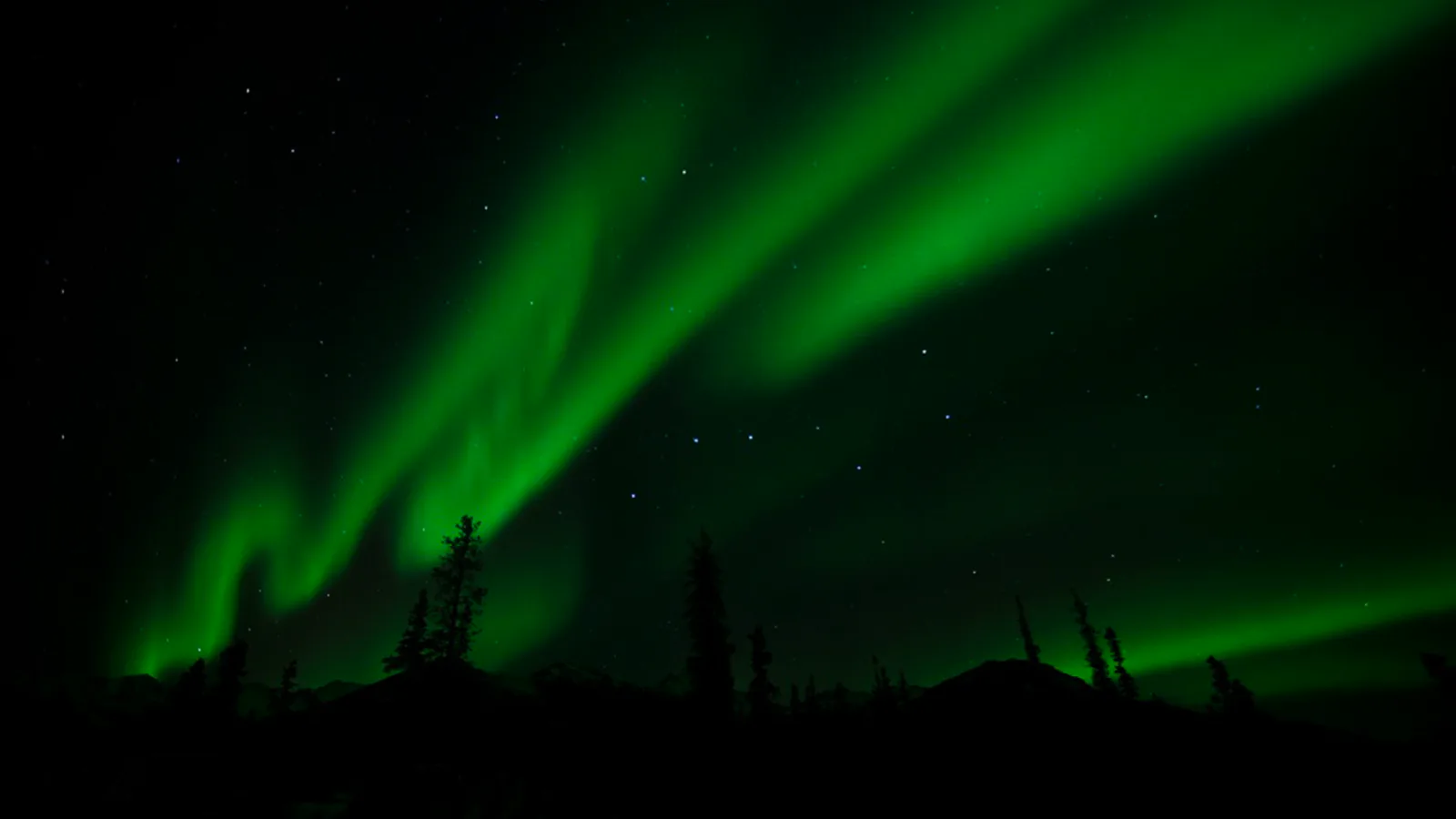
Denali does not have a trail at every bus stop. Most of its six million acres remain trail-less, while a compact network near the entrance and Savage River gives day hikers a clear way onto the ground. That contrast matters: a signed forest path and an open tundra ridge may begin near the same road, yet ask for very different skills.
These seven hikes start with the entrance network, climb Mount Healy, reach Savage River by shuttle, and finish with the rougher Bison Gulch approach. The count stops at seven because the Nenana River Trail is still being built and its current length can change. A line on a map is not enough reason to send someone onto unfinished tread.
The Denali Park Road remains closed at Mile 43 through summer 2026 because of the Pretty Rocks landslide. That closure does not block the hikes below, which are at the entrance, along Highway 3, or at Savage River near Mile 15. Wildlife closures can appear with little notice, though, and some last less than a day. Ask at the visitor center before hiking even if the online map looked clear that morning.
What changes a hiking day here
Give wildlife the route
Stay at least 300 yards from bears and 25 yards from other animals. Hike in a group, make recognizable human noise in brush, carry accessible bear spray, and know how to use it. Never run from a bear or crowd a moose near a trail.
Use the bus for Savage River
Private vehicles can reach Mile 15, but parking is extremely limited. In summer 2026 the free Savage River Shuttle runs roughly every thirty minutes. Download the current schedule before arriving because service dates and hours change during the shoulder season.
Rain is a cold-weather problem here
Summer rain, wind, and near-freezing temperatures can produce hypothermia. Carry a waterproof shell and insulating layers even on a bright morning. Snow can fall in almost any month, especially on the ridges.
Pets cannot use these trails
Leashed pets are generally limited to roads, parking areas, campground roads, and the Roadside Hiking and Bike Trails. They are not permitted on the hikes in this guide or on park buses.
| Trail | Distance | Time | Difficulty | Best for |
|---|---|---|---|---|
| Spruce Forest Loop | 0.5 mi | 1 hr | Easy | A gentle introduction to Denali's boreal forest |
| McKinley Station Trail | 3.1 mi | 1 hr 30 min | Easy | Railroad and early park history on forgiving tread |
| Horseshoe Lake and Beaver Dam Loop | 3.1 mi | 2 hr | Moderate | A lake circuit with beaver activity and river views |
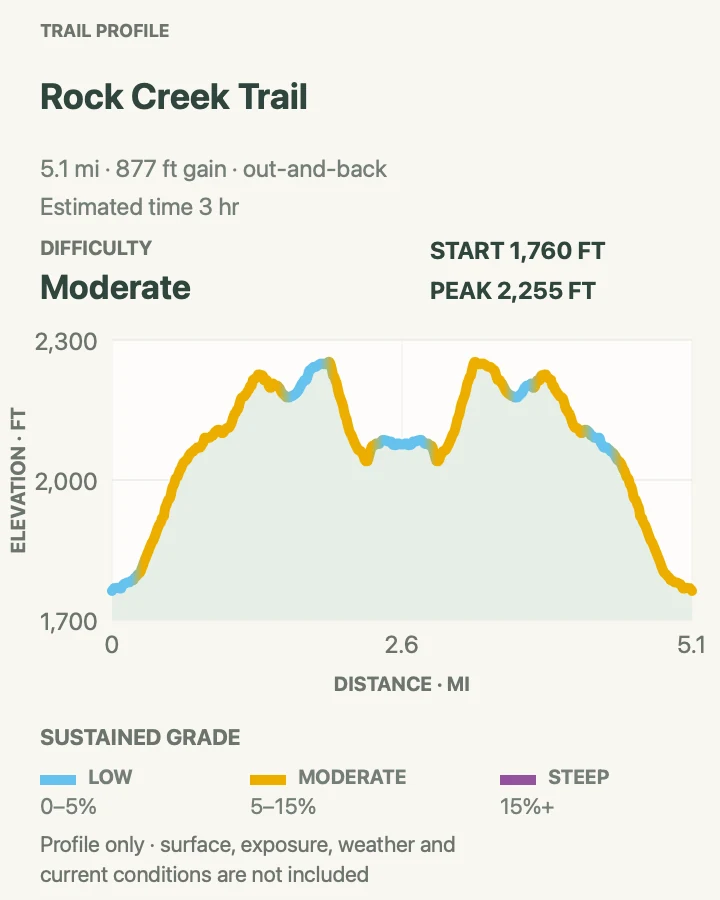
| Rock Creek Trail | 5.2 mi | 3 hr | Moderate | A longer boreal-forest walk close to park services |
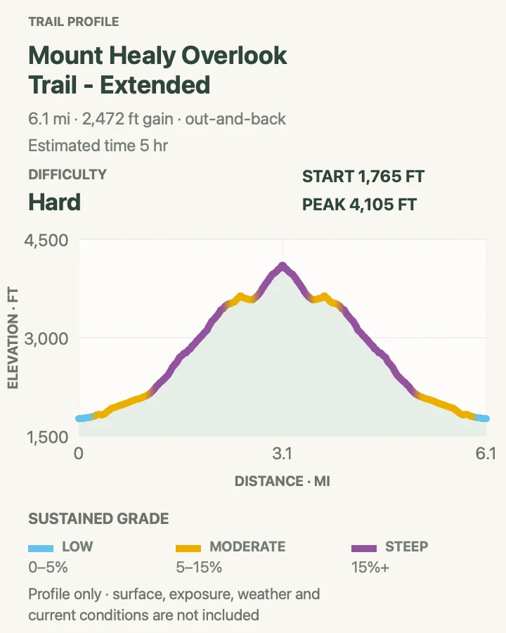
| Mount Healy Overlook and Ridge Extension | 6.3 mi | 5 hr | Hard | A strenuous climb from forest to exposed alpine ridge |
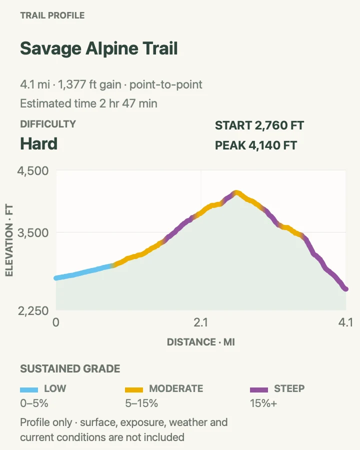
| Savage Alpine Trail | 4.2 mi | 2 hr 47 min | Hard | A point-to-point tundra traverse with broad park views |
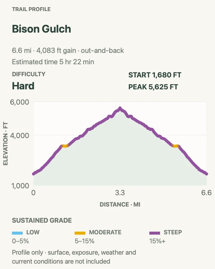
| Bison Gulch and Healy Ridge | 6.9 mi | 5 hr 22 min | Strenuous | Experienced hikers seeking a steep off-trail ridge day |
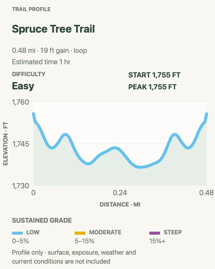
Spruce Forest Loop
- Distance
- 0.5 mi
- Elevation gain
- 20 feet
- Time
- 1 hr
- Difficulty
- Easy
- Route type
- loop
- Parking
- Begin at the Denali Visitor Center and follow signs for the short Spruce Forest loop.
- Best time
- Any open visitor-center day; early morning is quiet and often good for listening to birds.
- Pets
- Pets are not allowed on park trails. Trained service animals are allowed.
The half-mile loop stays close to the visitor center but drops quickly into the texture of black spruce, moss, and low forest. Compacted gravel and a level grade make it the easiest walk in this collection.
Easy tread does not remove wildlife. Moose can feed close to developed areas, especially where brush limits sightlines. Back away and choose another path if an animal occupies the trail.
What helps on this route
- Use this as a weather check before committing to Mount Healy.
- Make conversation around blind bends instead of relying on a bear bell.
Terrain and access: Level compacted gravel, narrow boreal forest, low brush, damp ground, and developed trail junctions near the visitor center.

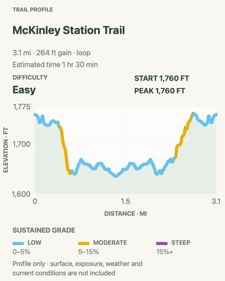
McKinley Station Trail
- Distance
- 3.1 mi
- Elevation gain
- 260 feet
- Time
- 1 hr 30 min
- Difficulty
- Easy
- Route type
- loop
- Parking
- Start at the Denali Visitor Center or Riley Creek Campground; use the shuttle if returning to a different entrance-area stop.
- Best time
- A cool morning or an afternoon between ranger programs.
- Pets
- Pets are not allowed on park trails. Trained service animals are allowed.
McKinley Station links the visitor center and Riley Creek through spruce woods, past Hines and Riley Creeks, and beneath the Alaska Railroad trestle. The mapped loop adds entrance-area connectors so the walk returns without simply retracing every step.
The main trail is wide compacted gravel with a long gentle descent. Trains, wet bridges, and creek edges still deserve attention. Use signed crossings and keep children together beneath the trestle.
What helps on this route
- Read the station-history panels slowly; they give the route more purpose than its modest mileage suggests.
- Check the Riley Creek shuttle loop if you do not want to walk the connector back.
Terrain and access: Compacted gravel, gentle grades, creek bridges, railroad underpass, forest, and linked entrance-area paths.

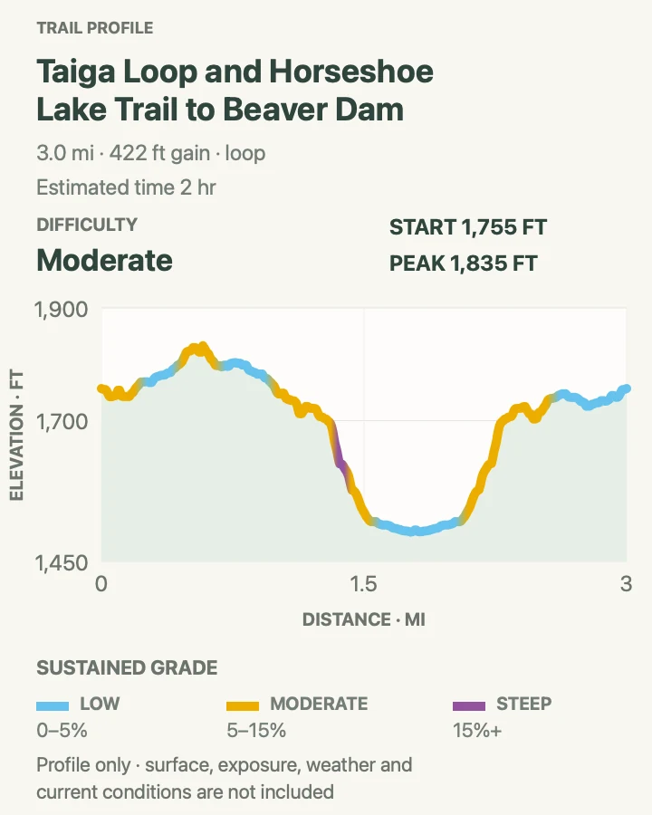
Horseshoe Lake and Beaver Dam Loop
- Distance
- 3.1 mi
- Elevation gain
- 420 feet
- Time
- 2 hr
- Difficulty
- Moderate
- Route type
- loop
- Parking
- Use the small Mile 1 lot only when a legal space is open, or start from the Denali Visitor Center for the mapped longer loop.
- Best time
- Morning or evening, when the lake is calmer and wildlife is easier to observe from a distance.
- Pets
- Pets are not allowed on park trails. Trained service animals are allowed.
The trail drops steeply from the entrance bench to Horseshoe Lake, then circles the shore with a short spur to a beaver dam and a stretch beside the Nenana River. The water and forest make it feel removed from the road despite the close trailhead.
Most of the elevation is packed into the return climb. Roots and uneven soil replace the entrance gravel, and the west shore crosses a steep hillside. Beaver, moose, or bear activity can close part of the loop without warning.
What helps on this route
- If the tiny Mile 1 lot is full, do not create a roadside space; use the visitor-center start or shuttle.
- Watch wildlife from the platforms and do not approach the dam.
Terrain and access: Steep forest descent, roots, uneven soil, lake shore, narrow hillside, viewing platforms, river edge, and a sustained climb out.

Rock Creek Trail
- Distance
- 5.2 mi
- Elevation gain
- 880 feet
- Time
- 3 hr
- Difficulty
- Moderate
- Route type
- out-and-back
- Parking
- Begin at the Denali Visitor Center trail system; the route can be linked with Roadside Trail for a point-to-point alternative.
- Best time
- Late August for aspen color, or a dry summer morning for firmer tread.
- Pets
- Pets are not allowed on park trails. Trained service animals are allowed.
Rock Creek winds through spruce, aspen, and birch with repeated small rises above the entrance road. It is a useful middle-distance outing for a day when cloud hides the mountain ridges.
The path is narrower and rougher than McKinley Station, with roots, damp soil, and occasional steep-sided sections. Meadow View and Roadside intersections make several combinations possible; keep the intended return clear at each junction.
What helps on this route
- Photograph the entrance trail map before leaving the visitor center.
- Make extra noise where creek sound and brush reduce warning for wildlife.
Terrain and access: Boreal forest, roots, compacted soil, rolling grade, creek noise, narrow side slopes, and signed connector junctions.

Mount Healy Overlook and Ridge Extension
- Distance
- 6.3 mi
- Elevation gain
- 2,470 feet
- Time
- 5 hr
- Difficulty
- Hard
- Route type
- out-and-back
- Parking
- Park at the Denali Visitor Center and reach the Mount Healy junction by the Taiga and Horseshoe Lake trail connection.
- Best time
- A clear, dry morning with light wind and no thunder in the forecast.
- Pets
- Pets are not allowed on park trails. Trained service animals are allowed.
The maintained trail climbs about 2.7 miles to the official overlook, gaining roughly 1,700 feet as spruce gives way to tundra and a broad view south. The 6.3-mile map continues a short distance beyond that endpoint to show the ridge extension recorded in the trail library.
Beyond the overlook there is no maintained trail. The ridge becomes steeper, looser, and more exposed, and people have died in falls on Mount Healy. The overlook is the correct turnaround for most hikers; continuing requires off-trail judgment and comfort with terrain that cannot be made safe by a GPX line.
What helps on this route
- Do not cut the switchbacks below the overlook; the shortcuts erode quickly and have worse footing.
- Turn back at the official endpoint in strong wind, wet rock, fog, or snow.
Terrain and access: Steep maintained switchbacks to the overlook, roots and rock, alpine wind, then optional loose off-trail ridge with severe fall exposure.

Savage Alpine Trail
- Distance
- 4.2 mi
- Elevation gain
- 1,380 feet
- Time
- 2 hr 47 min
- Difficulty
- Hard
- Route type
- point-to-point
- Parking
- Ride the free Savage River Shuttle and use the Mountain Vista and Savage River stops; parking at Mile 15 is extremely limited.
- Best time
- A clear summer morning when shuttles are operating and ridge wind is moderate.
- Pets
- Pets are not allowed on park trails. Trained service animals are allowed.
Savage Alpine crosses the ridge between Mountain Vista and Savage River, gaining its height quickly and holding open tundra views before a steep descent. A clear day may reveal Denali, though the route remains worthwhile for the near ridges and river valley when the summit is hidden.
This is a point-to-point trail, so transportation is part of the hike. Confirm the direction, shuttle stop, and final service time before setting out. Wind and weather are more consequential above treeline than the four-mile distance implies.
What helps on this route
- Many hikers start at Mountain Vista and finish at Savage River, but use the direction that matches wind and shuttle timing.
- Carry layers in the pack rather than tying them outside where the ridge wind can take them.
Terrain and access: Steep tundra climb, exposed alpine ridge, loose rock, sustained descent, wind, and separate shuttle-served trailheads.

Bison Gulch and Healy Ridge
- Distance
- 6.9 mi
- Elevation gain
- 4,080 feet
- Time
- 5 hr 22 min
- Difficulty
- Strenuous
- Route type
- out-and-back
- Parking
- Use the signed Highway 3 pullout near Bison Gulch without crossing or blocking private property; confirm the access point with a ranger.
- Best time
- A dry, clear summer day with long daylight and low wind.
- Pets
- Pets are not allowed on park trails. Trained service animals are allowed.
Bison Gulch climbs from the Parks Highway toward the east end of Mount Healy's ridge system. The route moves from brush and creekbed travel to loose alpine ground, eventually opening views across the entrance area and Nenana valley.
This is not a maintained national-park trail. Private land borders parts of the approach, the ridge footing is precarious, and the recorded line does not guarantee a legal or safe passage on the day. Ask a ranger about access, carry navigation tools, and turn around before a scramble you cannot reverse.
What helps on this route
- Do not assume every visible track from the highway is public access.
- Travel with a partner, leave a route plan, and carry bear spray where it can be reached immediately.
Terrain and access: Unmaintained gulch, brush, creekbed, steep loose scree, alpine ridge, route finding, private-property boundary, and serious fall exposure.

Official planning sources
Trail access and safety details were checked against these National Park Service pages. The maps and profiles use the reviewed route geometry stored with this guide.
- NPS: Current conditions and 2026 Park Road limits
- NPS: Day hiking and entrance-area trail directory
- NPS: Free bus routes and 2026 schedules
- NPS: Mount Healy Overlook Trail
- NPS: Horseshoe Lake Trail
- NPS: Savage River access
- NPS: Current closures
- NPS: Wildlife and bear safety
- NPS: Mount Healy backcountry unit
Map data © OpenStreetMap contributors. Trail geometry and planning details include National Park Service public information.