8 Best Hikes in Channel Islands National Park
Eight Channel Islands hikes across Anacapa, Santa Cruz, and San Miguel, with reviewed maps, elevation profiles, ferry timing, and live park alerts.
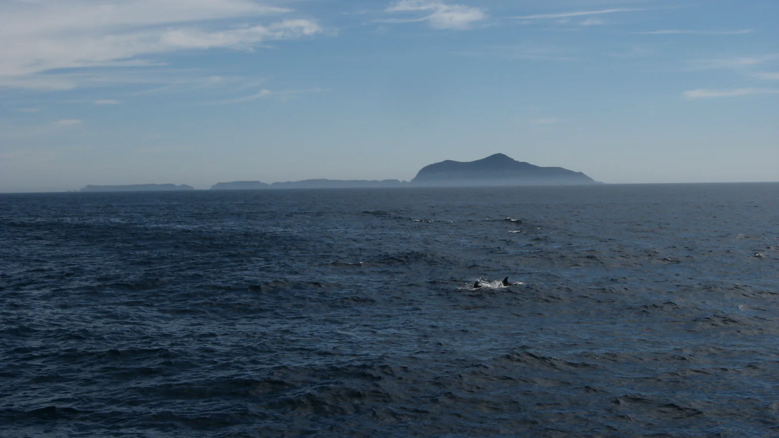
At Channel Islands, the boat schedule is part of every hike. There are no island shuttles, stores, or last-minute rides between trailheads. A 7-mile route is reasonable only when it fits between the landing briefing and the boat's boarding time.
Santa Cruz receives the most service and supports the widest range of independent walks. East Anacapa has a compact trail network after a steep stairway from the landing. San Miguel is wilder: access beyond the ranger station requires an escort because the island was once a bombing range. Each island is a separate trip.
Santa Rosa is deliberately absent from this edition. A May–June 2026 wildfire burned about a third of the island, and recovery closures still affect trails, beaches, and overnight use. Day trips have resumed, but a live ranger briefing is more useful there right now than a fixed best-hikes list.
What changes a hiking day here
Book transportation before choosing mileage
Island Packers serves the park from the mainland, but destinations and return times vary by day and season. Reserve the exact island landing, then choose a route that leaves a generous boarding margin. Weather can delay, reroute, or cancel a landing.
Water is an island-by-island fact
Scorpion Anchorage has potable water; Prisoners Harbor and San Miguel do not. Anacapa has no public water. Carry the entire supply whenever the landing page says none is available, plus food and a warm layer for a delayed crossing.
Wind changes the difficulty
Exposed ridges can be calm at the pier and punishing an hour later. Fog erases distant landmarks, while clay roads become slick after rain. Turnaround time must protect the boat departure, not the hoped-for summit.
Leave mainland hitchhikers behind
Pets, bicycles, plants, soil, firewood, untreated walking sticks, corrugated boxes, and single-use grocery bags are prohibited from transport to the islands. Clean boots, packs, and tent stakes before boarding to avoid moving seeds and pathogens.
| Trail | Distance | Time | Difficulty | Best for |
|---|---|---|---|---|
| East Anacapa Island Loop | 2.4 mi | 1 hr 30 min | Easy | Seeing most of Anacapa on one compact circuit |
| Cavern Point Loop | 1.8 mi | 1 hr | Easy | A short first hike from Scorpion Anchorage |
| Potato Harbor | 5.3 mi | 2 hr 30 min | Moderate | Coastal mileage and a secluded cove view |
| Scorpion Canyon Loop | 4.3 mi | 2 hr 30 min | Moderate | An inland loop with island fox habitat |
| Smugglers Cove | 7.7 mi | 4 hr 30 min | Moderate | A long Santa Cruz walk to a remote beach |
| Prisoners Harbor to Del Norte | 6.2 mi | 4 hr | Moderate | Rugged north-coast views and backcountry character |
| Montañon Ridge Loop | 8.8 mi | 5 hr | Hard | Experienced hikers seeking the high interior of Santa Cruz |
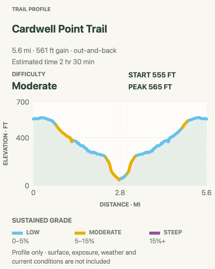
| Cardwell Point with a San Miguel Ranger | 5.6 mi | 2 hr 30 min | Moderate | A remote wildlife overlook with strict guided access |
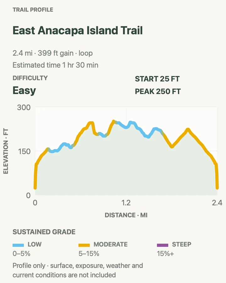
East Anacapa Island Loop
- Distance
- 2.4 mi
- Elevation gain
- 400 feet
- Time
- 1 hr 30 min
- Difficulty
- Easy
- Route type
- loop
- Parking
- There is no car trailhead. Begin at Landing Cove after the boat crew releases passengers, then climb the long metal stairway to the island top.
- Best time
- A calm-weather day trip; spring brings seabirds and wildflowers but also nesting closures and strong wind.
- Pets
- Pets are not allowed on park trails. Trained service animals are allowed.
East Anacapa's figure-eight path reaches Inspiration Point, Cathedral Cove, Pinniped Point, the lighthouse area, and views toward the other islets. The walking on top is gentle; the real climb is the stairway from the boat landing.
Cliff edges are crumbly, and nesting gulls can occupy ground beside the path. Stay on the trail, expect noise and guano during breeding season, and keep well clear of birds even when they refuse to move. Middle and West Anacapa are not open for hiking.
What helps on this route
- Carry water from the mainland; none is available on Anacapa.
- Do the farther Inspiration Point section first, then finish near the landing as departure time approaches.
Terrain and access: Landing stairs, gentle grassy plateau, narrow dirt paths, exposed sea cliffs, strong wind, and no shade or water.

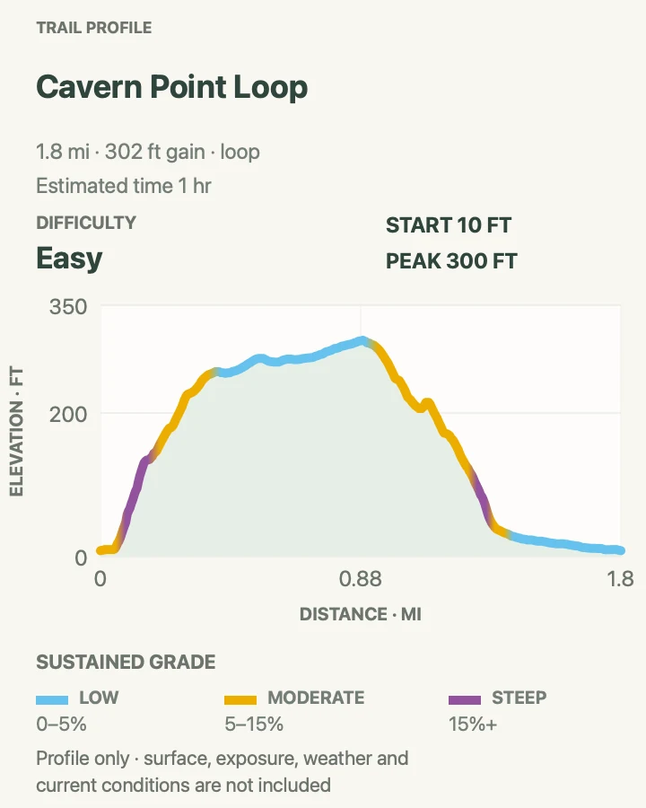
Cavern Point Loop
- Distance
- 1.8 mi
- Elevation gain
- 300 feet
- Time
- 1 hr
- Difficulty
- Easy
- Route type
- loop
- Parking
- Start at Scorpion Anchorage after landing; follow signs through the ranch area to either side of the loop.
- Best time
- Morning for softer light and cooler climbing; avoid the bluff in dangerous wind.
- Pets
- Pets are not allowed on park trails. Trained service animals are allowed.
Cavern Point climbs above Scorpion Anchorage to coastal bluffs with views of sea caves, Scorpion Rock, and the mainland. Returning through the ranch area makes an easy loop that fits many half-day boat schedules.
The steepest section is the climb from the campground side. Walking that direction first makes the loose grade an ascent rather than a descent. Stay back from undercut cliff edges and do not descend toward sea caves.
What helps on this route
- Climb from the campground and return on the gentler road side if loose descents bother you.
- Pair it with the ranch-house visitor center before boarding.
Terrain and access: Steep dirt climb, open coastal grassland, exposed bluffs, loose descent, signed junctions, and strong wind.

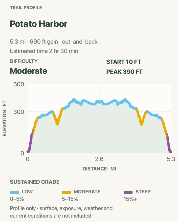
Potato Harbor
- Distance
- 5.3 mi
- Elevation gain
- 690 feet
- Time
- 2 hr 30 min
- Difficulty
- Moderate
- Route type
- out-and-back
- Parking
- Begin at Scorpion Anchorage; no ground transportation or separate trailhead parking exists on the island.
- Best time
- A clear morning with enough boat layover for five miles and viewpoint stops.
- Pets
- Pets are not allowed on park trails. Trained service animals are allowed.
Potato Harbor follows the marine terrace west from Scorpion, passing the Cavern Point junction and rolling over open grassland. The finish looks down into a round, cliff-bound cove that has no hiker beach access.
There is no shade and almost no protection from west wind. The return retraces the same exposed ridge, so turn around based on the boat rather than how close the viewpoint seems.
What helps on this route
- Write the boarding time on your map and set an alarm for the turnaround.
- Bring binoculars; the cove and offshore water are better viewed from the rim than approached.
Terrain and access: Rolling dirt road and trail, open grassland, cliff-edge viewpoint, no shade, no water, and sustained wind.

Scorpion Canyon Loop
- Distance
- 4.3 mi
- Elevation gain
- 820 feet
- Time
- 2 hr 30 min
- Difficulty
- Moderate
- Route type
- loop
- Parking
- Walk inland from Scorpion Anchorage through the ranch and campground to the signed canyon trail.
- Best time
- Late winter or spring for green hills and flowers, or a cool morning in other seasons.
- Pets
- Pets are not allowed on park trails. Trained service animals are allowed.
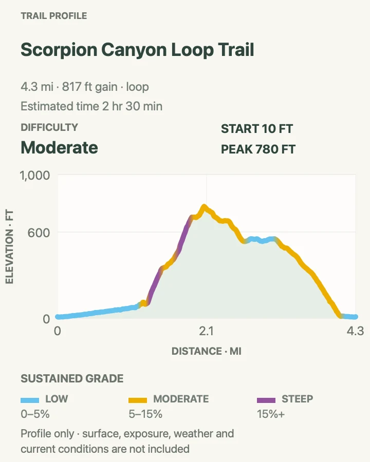
Scorpion Canyon trades the immediate coast for a sheltered valley, dry creek crossings, and a climb onto the plateau. The return road opens views back toward the anchorage and the northern coast.
Island foxes often move around the campground and ranch. Keep food zipped and never feed them; an unattended pack can become a reward in seconds. Rain turns the clay tread slick.
What helps on this route
- Secure every snack before leaving the picnic area, even for a short stop.
- Use the canyon first on hot or windy days, then return by the more exposed road.
Terrain and access: Dry creek bed, shaded canyon patches, clay tread, rolling climb, open plateau road, and several ranch junctions.

Smugglers Cove
- Distance
- 7.7 mi
- Elevation gain
- 1,440 feet
- Time
- 4 hr 30 min
- Difficulty
- Moderate
- Route type
- out-and-back
- Parking
- Start at Scorpion Anchorage and follow Smugglers Road over the island spine; there is no vehicle shuttle back.
- Best time
- A cool full-day landing with an early start and mild wind.
- Pets
- Pets are not allowed on park trails. Trained service animals are allowed.
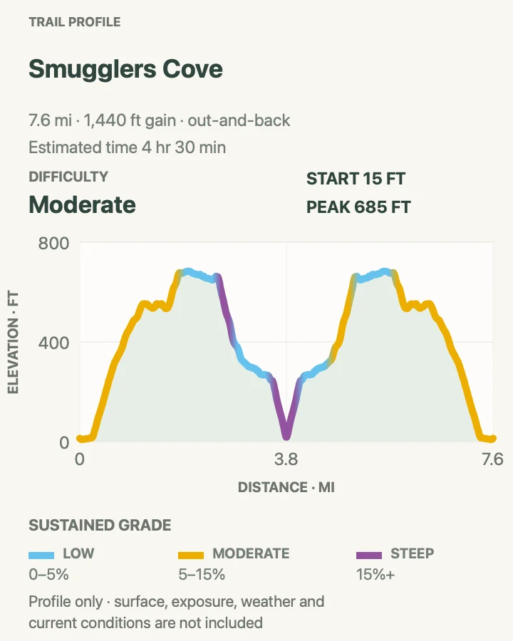
The old ranch road climbs steadily from Scorpion, crosses the island's dry interior, and descends to a cobble-and-sand cove with historic ranch remnants. Ocean views appear on both sides near the high point.
The climb back from the beach is the trap. Leave Smugglers with ample time and water rather than treating the shore as the halfway rest. Tide, surf, and falling rock make the base of the cliffs a poor place to linger.
What helps on this route
- Begin returning earlier than the mileage alone suggests; the exposed climb comes after the beach.
- Do not count on shade or water beyond Scorpion Anchorage.
Terrain and access: Broad dirt ranch road, sustained climbs, open dry hills, steep return from the cove, no shade, and beach cobbles.

Prisoners Harbor to Del Norte
- Distance
- 6.2 mi
- Elevation gain
- 1,600 feet
- Time
- 4 hr
- Difficulty
- Moderate
- Route type
- out-and-back
- Parking
- Begin at the Prisoners Harbor pier after landing; carry all water because none is available at Prisoners or Del Norte.
- Best time
- A cool-weather day with a long Prisoners Harbor layover, or as the approach to a reserved overnight stay.
- Pets
- Pets are not allowed on park trails. Trained service animals are allowed.
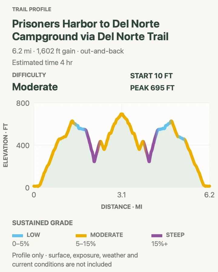
Del Norte Trail climbs sharply from Prisoners Harbor, then traverses high ground above the north coast to the park's small backcountry campground. The route passes scrub-jay habitat and feels more remote than the maintained Scorpion roads.
The mapped out-and-back is difficult to fit into a short day-boat schedule. Confirm the exact departure before starting, and remember that the campground has a table, food box, and toilet but no water. Stay on NPS property at the marked boundary with The Nature Conservancy.
What helps on this route
- Do not attempt the full out-and-back when the scheduled island time leaves no delay margin.
- Carry every drop from the mainland and keep food protected from foxes and ravens.
Terrain and access: Steep initial climb, narrow dirt trail, rolling coastal ridge, sparse shade, signed property boundary, and no water.

Montañon Ridge Loop
- Distance
- 8.8 mi
- Elevation gain
- 1,830 feet
- Time
- 5 hr
- Difficulty
- Hard
- Route type
- loop
- Parking
- Start at Scorpion Anchorage and use the Scorpion Canyon and Montañon trail network; verify every boundary and junction on the current island map.
- Best time
- A long, clear day with light wind and an early boat arrival.
- Pets
- Pets are not allowed on park trails. Trained service animals are allowed.
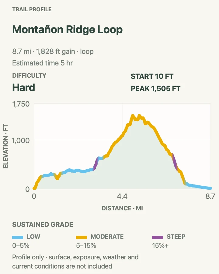
Montañon Ridge climbs beyond the usual Scorpion day-hike circuit into rugged interior hills. The high route gives views across Santa Cruz and toward neighboring islands, then returns through a different branch of the trail network.
This is not the place to chase a fading path. Parts of eastern Santa Cruz border The Nature Conservancy property, where independent park visitors may not hike. Fog and grass can obscure tread, and the full loop demands a generous boat-time margin.
What helps on this route
- Download the NPS map before leaving Ventura and carry offline navigation as backup.
- Abandon the ridge goal when fog, wind, or pace threatens the boat deadline.
Terrain and access: Steep ranch roads, narrow mountain paths, exposed ridge, route-finding, long climbs, no shade, and boundary constraints.

Cardwell Point with a San Miguel Ranger
- Distance
- 5.6 mi
- Elevation gain
- 560 feet
- Time
- 2 hr 30 min
- Difficulty
- Moderate
- Route type
- out-and-back
- Parking
- Land at Cuyler Harbor, complete the island permit process, and join an authorized ranger or volunteer hike; independent access beyond the ranger station is prohibited.
- Best time
- A scheduled summer or fall San Miguel trip when staff, sea, and wind allow the escorted hike.
- Pets
- Pets are not allowed on park trails. Trained service animals are allowed.
Cardwell Point crosses San Miguel's windswept plateau to an overlook above seal and sea-lion habitat. The island's recovery from ranching and its exposed ocean position make the walk feel unlike Santa Cruz, even before the wildlife comes into view.
The route is ranger-only because San Miguel was a naval bombing range and unexploded ordnance may remain. Do not follow the map independently. Boat landings can involve a skiff and wet beach exit, and thirty-knot wind is ordinary rather than exceptional.
What helps on this route
- Confirm that a ranger-led Cardwell hike is offered on the specific trip before assuming it will happen.
- Bring all water, secure a low-profile hat, and obey every wildlife-distance instruction.
Terrain and access: Steep climb from Cuyler Harbor, open plateau, dirt and gravel tread, extreme wind, no water, and ranger-controlled access.

Official planning sources
Trail access and safety details were checked against these National Park Service pages. The maps and profiles use the reviewed route geometry stored with this guide.
Map data © OpenStreetMap contributors. Trail geometry and planning details include National Park Service public information.