4 Best Hikes and Walks in Biscayne National Park
Four honest Biscayne walks on the mainland edge, Boca Chita Key, and Elliott Key, with reviewed maps, elevation profiles, boat-access notes, and live park alerts.
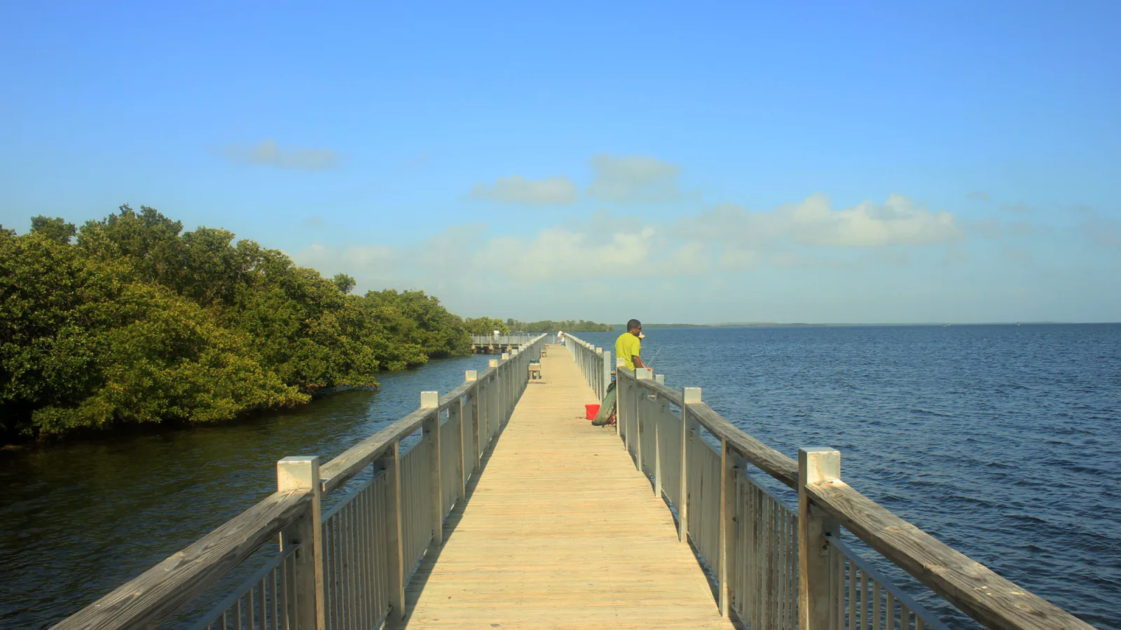
Biscayne protects water first: bay, mangrove shoreline, keys, and coral reef. Its useful hiking list is therefore short. One route begins on the mainland edge, while the three island walks require a private boat or an authorized excursion. The boat plan is part of the trail plan.
These four routes are not ranked. Boca Chita is the compact lighthouse-and-harbor walk. Elliott Key has both a short interpretive loop and a longer trip along the old Spite Highway. Black Creek Canal provides an accessible mainland alternative near the park boundary, although its trailhead is in a Miami-Dade County facility rather than an NPS visitor area.
Elevation barely changes here, but exposure does. Sun, humidity, mosquitoes, storm surge, rough water, and the lack of supplies on the keys determine whether a flat mile feels easy. Check the live NPS alerts, marine forecast, and return transportation before leaving the dock.
What changes a hiking day here
Three walks begin with a boat ride
Boca Chita and Elliott Key have no road connection. Confirm the exact island, dock, return time, and baggage rules with the authorized operator or boat captain before treating a route as available. A trail can be open while wind or seas cancel transportation.
Carry the island supplies
Boca Chita has no drinking water, electricity, shop, sink, or shower. Elliott Key normally has purified water at spigots, but a service interruption should not become an emergency. Carry water, food, sun protection, insect repellent, and a rain layer from the mainland.
Flat does not mean comfortable
All four routes stay close to sea level. Heat index, stagnant air in hardwood hammock, muddy ground, roots, mosquitoes, and no-see-ums matter more than grade. Thunderstorms and tropical systems can quickly make docks, low paths, and open shoreline poor places to be.
Pet rules change by island
Leashed pets are allowed at Convoy Point and on Elliott Key. Pets other than service animals are prohibited on Boca Chita Key, including on boats docked in its harbor. Boat operators may have stricter rules, so confirm before boarding.
| Trail | Distance | Time | Difficulty | Best for |
|---|---|---|---|---|
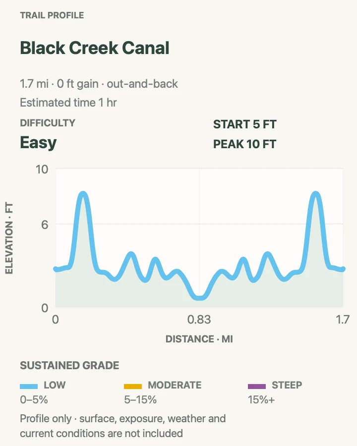
| Black Creek Canal and Jetty Walk | 1.7 mi | 1 hr | Easy | A mainland water walk without arranging a boat |
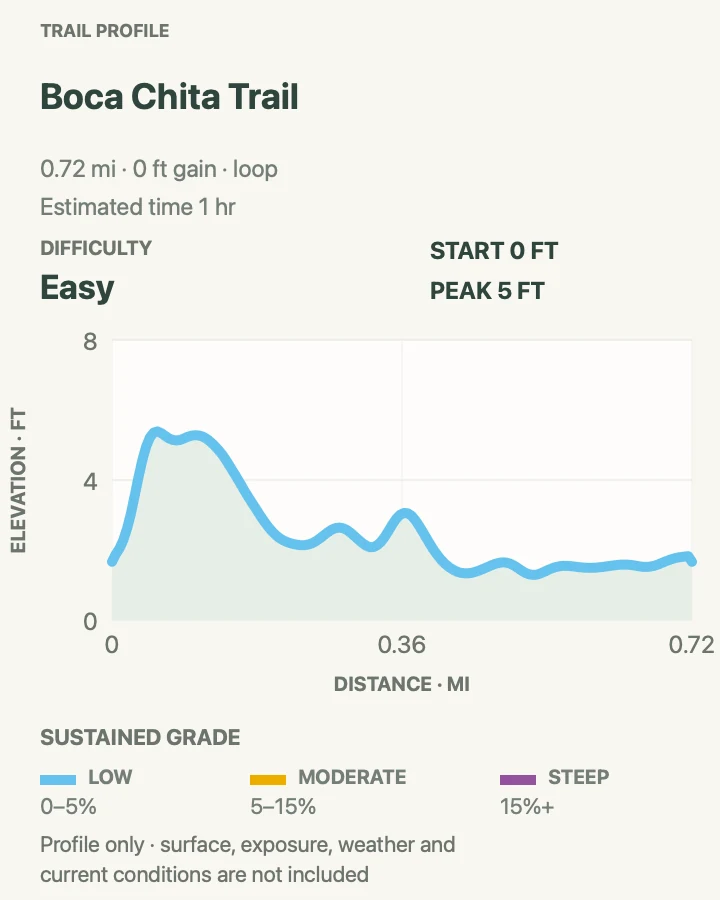
| Boca Chita Key Perimeter Trail | 0.7 mi | 1 hr | Easy | A short island circuit around the historic lighthouse |
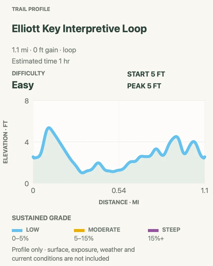
| Elliott Key Interpretive Loop | 1.1 mi | 1 hr | Easy | A compact sample of Elliott Key's hardwood hammock |
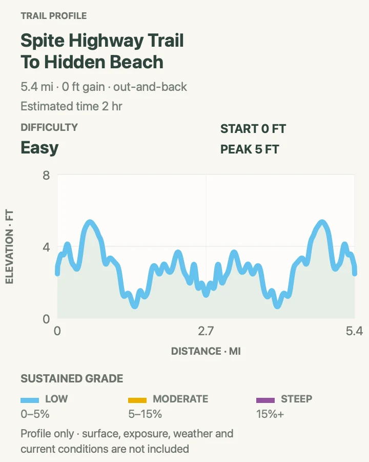
| Spite Highway to the Ocean Side | 5.4 mi | 2 hr | Easy | A longer walk across Elliott Key to the Atlantic side |
Black Creek Canal and Jetty Walk
- Distance
- 1.7 mi
- Elevation gain
- 0 feet
- Time
- 1 hr
- Difficulty
- Easy
- Route type
- out-and-back
- Parking
- Use Black Point Park and Marina, a Miami-Dade County facility beside Biscayne's mainland waters; observe county hours and marina parking rules.
- Best time
- Sunrise or a breezy winter morning before heat and afternoon storms build.
- Pets
- Leashed pets are allowed under Miami-Dade park rules; confirm current local restrictions. Trained service animals are allowed.
This out-and-back follows the Black Creek channel through the marina and onto the long jetty toward Biscayne Bay. Mangroves line parts of the route, while pelicans, herons, and anglers concentrate near open water.
It sits at the park's mainland edge rather than beginning at an NPS visitor center. That distinction matters: Miami-Dade manages the parking and land facilities, and the path can be busy with fishing gear, bicycles, marina traffic, and wet surfaces.
What helps on this route
- Yield space to people casting from the jetty and keep clear of hooks and fishing line.
- Treat lightning over the bay as a reason to turn around immediately.
Terrain and access: Paved and firm waterfront path, bridges and jetty, full sun, sea spray, fishing activity, and negligible elevation change.

Boca Chita Key Perimeter Trail
- Distance
- 0.7 mi
- Elevation gain
- 0 feet
- Time
- 1 hr
- Difficulty
- Easy
- Route type
- loop
- Parking
- Arrive by private boat or an authorized boat excursion and use only the marked harbor docking area.
- Best time
- A dry winter morning or the cooler portion of a scheduled island visit.
- Pets
- Pets other than service animals are not permitted anywhere on Boca Chita Key or on boats in its harbor.
The Boca Chita walk leaves the harbor near the restrooms, crosses tropical vegetation, and loops around the island's southern end toward the pavilion. The ornamental lighthouse is the landmark, but its observation deck opens only when park or authorized staff are present.
A short distance hides real island constraints. There is no drinking water, mosquitoes are present year-round, and the unpaved perimeter includes a small bridge with three steps on each side. Pack out every piece of trash.
What helps on this route
- Do not count on lighthouse access; the ground-level walk stands on its own.
- Bring all water from the mainland and keep food secured from wildlife.
Terrain and access: Unpaved grass and coral-rock path, short bridge steps, roots, insects, open shoreline, and virtually no climbing.

Elliott Key Interpretive Loop
- Distance
- 1.1 mi
- Elevation gain
- 0 feet
- Time
- 1 hr
- Difficulty
- Easy
- Route type
- loop
- Parking
- Reach Elliott Key by private boat or an authorized excursion and start near the harbor and campground area.
- Best time
- A cool dry-season morning after confirming dock and island facilities.
- Pets
- Leashed pets are allowed on Elliott Key, subject to boat-operator rules. Trained service animals are allowed.
This short loop begins near Elliott Key Harbor and passes through tropical hardwood hammock before returning toward the developed island area. It gives boat visitors a land-based look at gumbo limbo, mahogany, ironwood, and the low coral foundation of the key.
The path is not paved. Roots, leaf litter, standing water, storm debris, and insects can matter despite a profile measured in feet. Purified water is normally available at spigots near park buildings, but carrying a reserve avoids dependence on a remote system.
What helps on this route
- Wear closed shoes even though the route is flat; coral rock and roots are unforgiving in sandals.
- Check skin and clothing for ticks after leaving dense vegetation.
Terrain and access: Natural island tread, roots, leaf litter, coral rock, seasonal mud or standing water, dense shade, and heavy insects.


Official planning sources
Trail access and safety details were checked against these National Park Service pages. The maps and profiles use the reviewed route geometry stored with this guide.
Map data © OpenStreetMap contributors. Trail geometry and planning details include National Park Service public information.