9 Best Hikes in Cuyahoga Valley National Park
Nine Cuyahoga Valley hikes to waterfalls, sandstone ledges, ravines, and quiet woods, with reviewed maps, elevation profiles, and live park alerts.
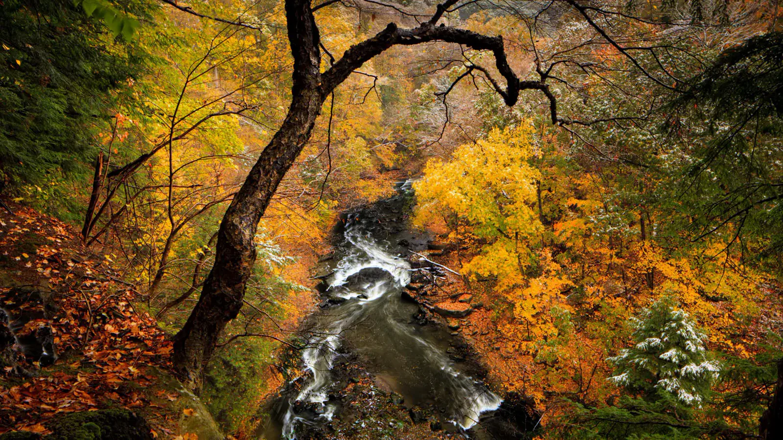
Cuyahoga Valley is not one contiguous wilderness trail system. Roads, towns, rail lines, Metro Parks, towpath segments, and national-park woods interlock across the valley. The useful way to choose a hike is by trailhead and ground conditions, not by assuming every waterfall and ledge can be linked in one day.
These nine routes spread the attention around. Brandywine is the famous short stop; Blue Hen earns its waterfall with a muddy Buckeye Trail approach; Ritchie Ledges supplies the park's most distinctive rock walk. Adam Run, Plateau, Deer Lick, and Wetmore are for quieter forest mileage.
Rain and construction reshape plans frequently. In late August 2026, Dickerson Run is closed, portions of the Towpath are under scheduled repair, Wetmore parking should be approached from Pine Hollow when its lot is unavailable, and Ice Box Cave remains closed to protect bats. The live alert panel below should be checked on the day of the hike.
What changes a hiking day here
Mud is normal, not an exception
Clay, ravine drainage, horse traffic, and frequent rain can turn a moderate loop into slow work. Use footwear that can leave dirty, avoid widening the trail around puddles, and skip vulnerable bridle routes after soaking storms.
Popular lots have no secret overflow
Brandywine and Blue Hen are busiest from late morning into afternoon. Park only in marked spaces; roadside parking can be ticketed or towed. Boston Mill Visitor Center is the correct start for Blue Hen.
A cave-shaped opening can still be closed
Ice Box Cave at Ritchie Ledges is closed to slow the spread of white-nose syndrome among bats. Stay out of the opening and do not cross closure signs. Decontaminate footwear if you have visited caves elsewhere.
Road crossings deserve a pause
Several valley routes cross active roads or emerge near traffic. The Blue Hen approach includes an unmarked road crossing. Stop, look both ways, and regroup children before anyone commits.
| Trail | Distance | Time | Difficulty | Best for |
|---|---|---|---|---|
| Brandywine Falls Boardwalk | 0.3 mi | 1 hr | Easy | The park's signature waterfall with minimal mileage |
| Blue Hen Falls from Boston Mill | 2.5 mi | 1 hr 30 min | Moderate | A small waterfall reached by a real hike |
| Ritchie Ledges Loop via Haskell Run | 2.7 mi | 1 hr 30 min | Moderate | Sandstone cliffs, passages, and the park's best geology walk |
| Pine Grove Trail | 2.1 mi | 42 min | Easy | An easy woodland loop without waterfall crowds |
| Deer Lick Cave and Buckeye Loop | 4.2 mi | 2 hr | Moderate | A longer ravine loop with rock shelters |
| Adam Run Trail | 3.4 mi | 1 hr 30 min | Moderate | A quieter wooded loop with steady hills |
| Plateau Trail | 4.7 mi | 1 hr 41 min | Moderate | Steady forest mileage on the west side of the valley |
| Wetmore Trail | 9.5 mi | 4 hr 30 min | Moderate | Long bridle-trail mileage and fewer people |
| Tinker's Creek Gorge Overlook Walk | 5.1 mi | 2 hr 30 min | Moderate | A northern gorge outing tied to the wider valley park system |
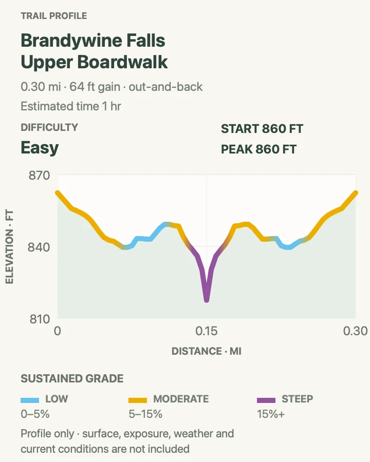
Brandywine Falls Boardwalk
- Distance
- 0.3 mi
- Elevation gain
- 65 feet
- Time
- 1 hr
- Difficulty
- Easy
- Route type
- out-and-back
- Parking
- Use the signed Brandywine Falls lot on Brandywine Road. There is no legal roadside overflow.
- Best time
- Before 10 a.m. or after 4 p.m.; weekdays are calmer than fine-weather weekends.
- Pets
- Pets are not allowed on park trails. Trained service animals are allowed.
The upper boardwalk reaches an unobstructed view of Brandywine Falls in a few minutes. A lower spur adds stairs and another angle over the 60-foot drop, but this mapped outing remains the accessible upper visit rather than the full gorge loop.
Short access brings crowds and risk-taking. Stay behind fences and at least fifty feet from the top and bottom of the falls. Climbing the rocks has caused severe injuries and deaths.
What helps on this route
- Return for the 1.4-mile Brandywine Gorge Loop only when you have the official area map and time for steep steps.
- Leave valuables out of sight or, better, out of the parked vehicle.
Terrain and access: Boardwalk and developed overlook, optional stairs, wet surfaces, heavy visitor traffic, and fenced waterfall views.

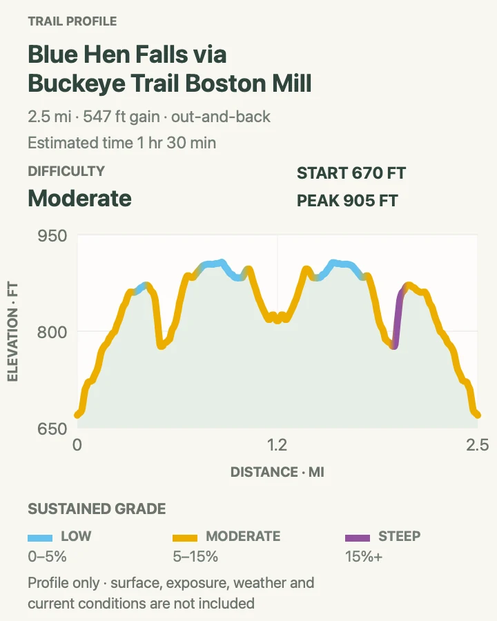
Blue Hen Falls from Boston Mill
- Distance
- 2.5 mi
- Elevation gain
- 550 feet
- Time
- 1 hr 30 min
- Difficulty
- Moderate
- Route type
- out-and-back
- Parking
- Park at Boston Mill Visitor Center or the Boston Trailhead, not along Boston Mills Road.
- Best time
- Early morning after a drier spell; spring flow is strong but the approach is muddier.
- Pets
- Pets are not allowed on park trails. Trained service animals are allowed.
The Buckeye Trail climbs out of Boston, crosses the road, and drops through forest to the ledge at Blue Hen Falls. The cascade is only about fifteen feet, but the ravine setting and hilly approach make it more satisfying than a parking-lot viewpoint.
Expect roots, rock, mud, and a steep final descent. The road crossing is not marked like a city crosswalk. Pause, listen, and cross as a group rather than following another party blindly.
What helps on this route
- Use Boston Mill restrooms and check the visitor-center board before starting.
- Stay on the signed trail at the falls; social paths damage the ravine and create slippery approaches.
Terrain and access: Hilly Buckeye Trail, roots, mud, road crossing, steep ravine descent, wet rock, and shaded forest.

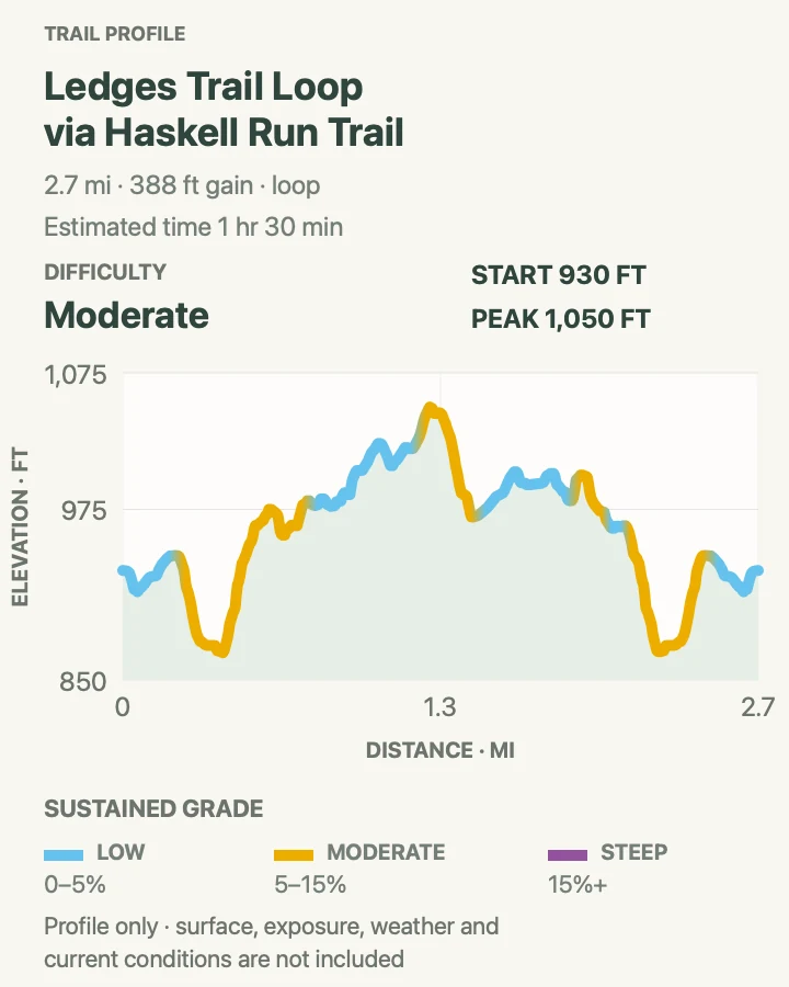
Ritchie Ledges Loop via Haskell Run
- Distance
- 2.7 mi
- Elevation gain
- 390 feet
- Time
- 1 hr 30 min
- Difficulty
- Moderate
- Route type
- loop
- Parking
- Use the large Ledges trailhead lot near the shelter on Kendall Park Road.
- Best time
- Morning in summer, or late afternoon for light on the west-facing overlook.
- Pets
- Pets are not allowed on park trails. Trained service animals are allowed.
This loop follows the base and top of the Sharon Conglomerate ledges, weaving past mossy walls, narrow passages, and overhangs before adding the Haskell Run connection. The terrain changes constantly despite modest mileage.
Rock climbing is prohibited, and Ice Box Cave is closed for bat protection. Treat both rules as resource protection, not suggestions. The top overlook has an abrupt edge and can be crowded near sunset.
What helps on this route
- Walk the lower ledges before the overlook if you want the best rock detail in quieter morning light.
- Do not enter Ice Box Cave or squeeze past closure barriers.
Terrain and access: Rocky forest trail, sandstone steps and passages, roots, damp moss, short climbs, and an exposed overlook.

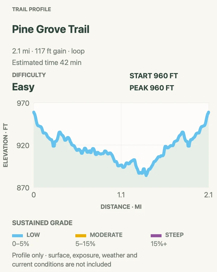
Pine Grove Trail
- Distance
- 2.1 mi
- Elevation gain
- 120 feet
- Time
- 42 min
- Difficulty
- Easy
- Route type
- loop
- Parking
- Begin at Octagon Shelter on Kendall Park Road, using the signed trailhead access.
- Best time
- Any dry season; it is especially pleasant on a warm afternoon when the forest is shaded.
- Pets
- Pets are not allowed on park trails. Trained service animals are allowed.
Pine Grove circles through mature forest near the Kendall area on gentler ground than the Ledges. It is a good choice when rocks are slick or when the group wants woods rather than a destination viewpoint.
Several nearby connectors can lengthen the walk. Follow Pine Grove signs at each junction if keeping to the mapped loop, and expect leaf cover to hide roots in autumn.
What helps on this route
- Photograph the trailhead map because the Kendall network has many tempting connectors.
- Listen for cyclists and horses only where shared-use connections approach.
Terrain and access: Rolling forest path, packed dirt, roots, seasonal leaf cover, gentle climbs, and signed trail junctions.

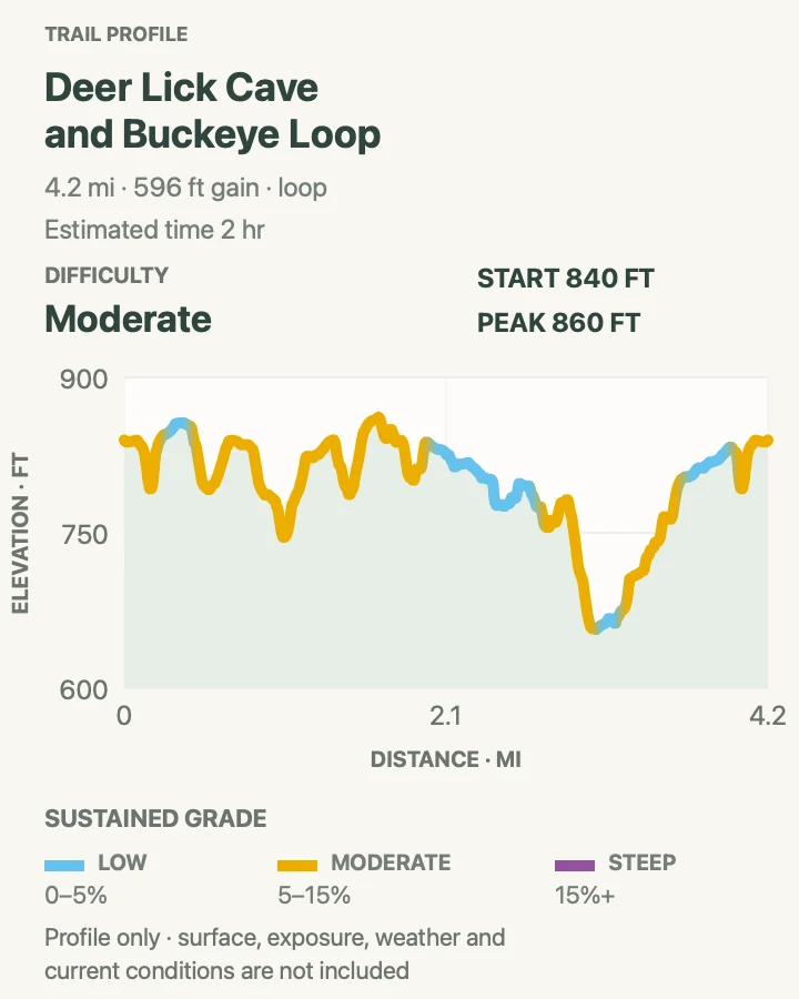
Deer Lick Cave and Buckeye Loop
- Distance
- 4.2 mi
- Elevation gain
- 600 feet
- Time
- 2 hr
- Difficulty
- Moderate
- Route type
- loop
- Parking
- Use the signed Brecksville Reservation trail access shown on the current park map; parking rules are managed with Cleveland Metroparks.
- Best time
- A dry morning in spring or fall, when ravine steps are less slick.
- Pets
- Pets are not allowed on park trails. Trained service animals are allowed.
This loop links Deer Lick's shallow rock shelter and creek valley with a section of the Buckeye Trail. Stairs and ravine crossings create more climbing than the low Ohio elevations suggest.
The word cave is generous: this is an overhang, not a cavern to explore. Keep off fragile ledges, yield at narrow bridges, and expect wet leaves to make stone steps slick after rain.
What helps on this route
- Choose this Buckeye combination instead of stacking it with the similar Bridle Loop in the same day.
- Carry traction in freeze-thaw weather; shaded ravines hold ice.
Terrain and access: Wooded ravines, stone and timber steps, creek crossings, roots, rock shelter, mud, and rolling Buckeye Trail.

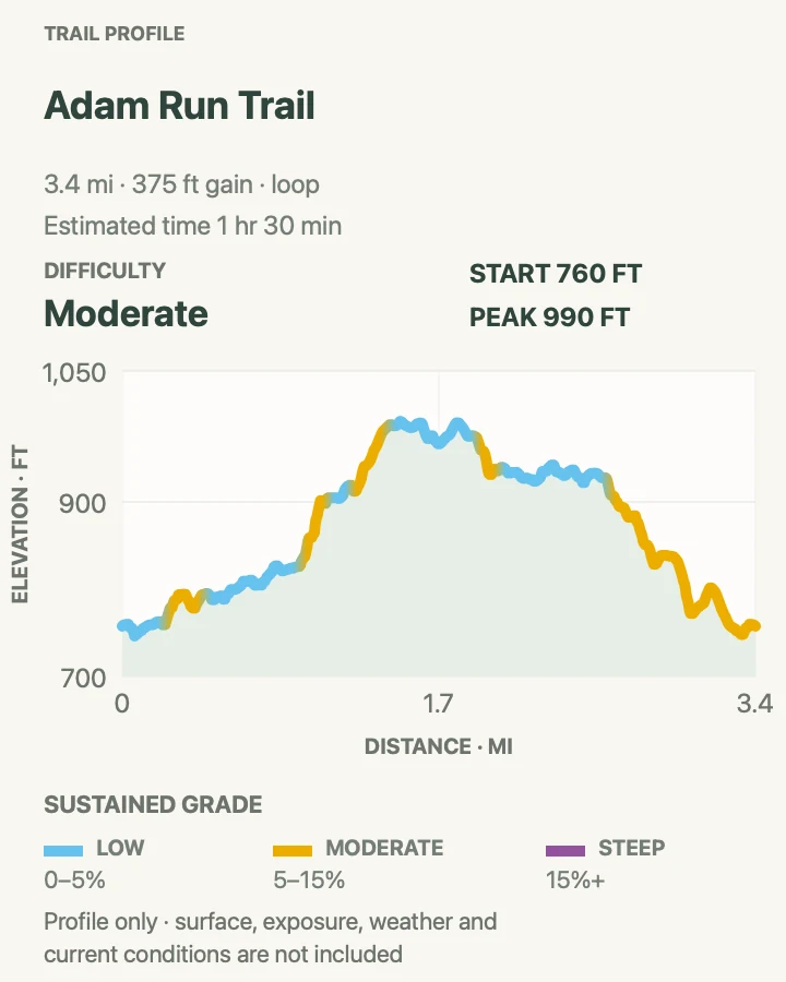
Adam Run Trail
- Distance
- 3.4 mi
- Elevation gain
- 370 feet
- Time
- 1 hr 30 min
- Difficulty
- Moderate
- Route type
- loop
- Parking
- Use the signed Hampton Hills trailhead and confirm Summit Metro Parks access notices before setting out.
- Best time
- A dry weekday morning, or autumn after the first leaves turn.
- Pets
- Pets are not allowed on park trails. Trained service animals are allowed.
Adam Run rolls through mixed forest and side ravines in the southern valley. It lacks a single marquee feature, which is part of its appeal when Brandywine and Ledges are full.
Short, repeated climbs accumulate on muddy tread. Blazes and shared trail junctions deserve attention, particularly when fallen leaves hide the path.
What helps on this route
- Skip the loop immediately after heavy rain to protect the tread and avoid churned mud.
- Carry the local park map because this trail connects with a wider reservation network.
Terrain and access: Rolling woodland, ravines, roots, clay mud, repeated short climbs, and shared-system junctions.

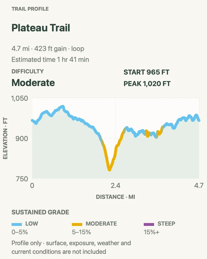
Plateau Trail
- Distance
- 4.7 mi
- Elevation gain
- 420 feet
- Time
- 1 hr 41 min
- Difficulty
- Moderate
- Route type
- loop
- Parking
- Use the Oak Hill area trailhead when Oak Hill Road access is open; current road detours may change the approach.
- Best time
- A dry cool day, avoiding the freeze-thaw season when horse tread becomes deeply muddy.
- Pets
- Pets are not allowed on park trails. Trained service animals are allowed.
Plateau loops through upland woods, old fields, and shallow ravines on a trail shared in places with equestrians. It provides a sustained walk without the concentrated visitor traffic of the waterfall corridors.
Oak Hill Road has an embankment closure in 2026, so follow the posted detour rather than trusting a saved driving route. Yield to horses, speak quietly, and step where the rider directs.
What helps on this route
- Check the road approach before leaving; the trail may be open while the usual drive is not.
- After wet weather, choose a firmer path rather than widening churned bridle tread.
Terrain and access: Upland forest, old fields, bridle trail, clay mud, shallow ravines, rolling grades, and road-access detour.

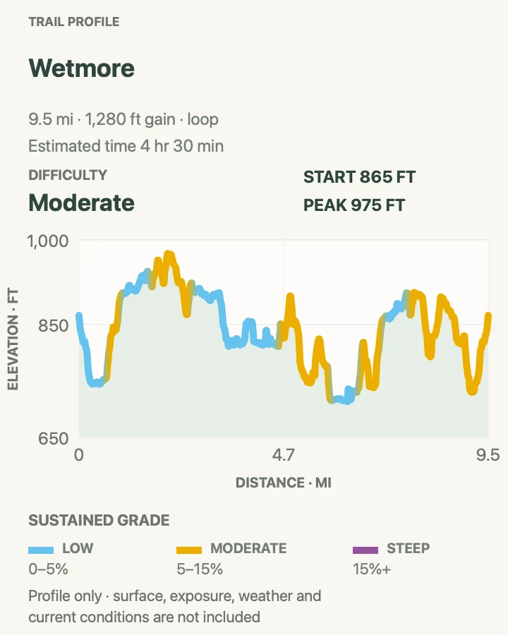
Wetmore Trail
- Distance
- 9.5 mi
- Elevation gain
- 1,280 feet
- Time
- 4 hr 30 min
- Difficulty
- Moderate
- Route type
- loop
- Parking
- Use Pine Hollow when the Wetmore trailhead lot is unavailable or unplowed, following the current condition notice.
- Best time
- A dry, cool day with enough time for a half-day loop.
- Pets
- Pets are not allowed on park trails. Trained service animals are allowed.
Wetmore strings together wooded ridges, stream valleys, and open patches west of the Ledges. Its nearly ten miles make it the endurance choice in this guide, though no single climb is severe.
Horse traffic and clay soil can create deep mud. Junctions make shortcuts possible but also invite wrong turns, so carry the official area map and know whether Pine Hollow has added distance to the recorded loop.
What helps on this route
- Yield early to horses and avoid sudden movements when standing beside the trail.
- Set a turnaround or shortcut decision before the halfway point if pace is slower than planned.
Terrain and access: Long bridle loop, forest ridges, creek valleys, clay mud, repeated rolling hills, and numerous junctions.

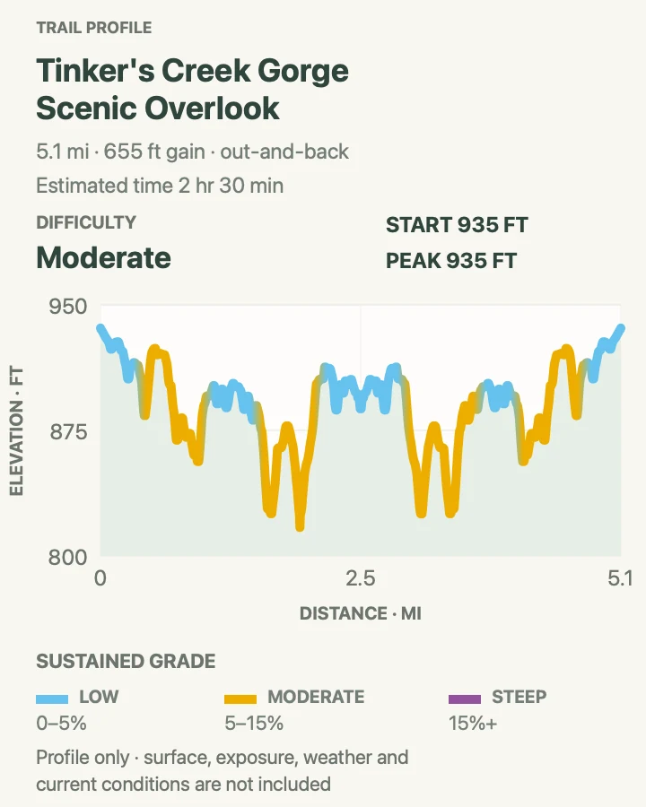
Tinker's Creek Gorge Overlook Walk
- Distance
- 5.1 mi
- Elevation gain
- 650 feet
- Time
- 2 hr 30 min
- Difficulty
- Moderate
- Route type
- out-and-back
- Parking
- Use legal Cleveland Metroparks parking for the Bedford Reservation approach shown on the route; verify local trail notices.
- Best time
- Spring for water flow or autumn for color, outside saturated or icy conditions.
- Pets
- Pets are not allowed on park trails. Trained service animals are allowed.
This out-and-back follows the wooded gorge system toward a high view over Tinker's Creek. It sits within the network of partner-managed parklands that connects the national park to the Cleveland greenbelt.
Because the approach crosses jurisdictions, signs and local closures outrank a single map layer. Water, ravine edges, and wet rock make detours tempting but unsafe; stay on the marked route.
What helps on this route
- Check both national-park and Cleveland Metroparks notices before driving to the trailhead.
- Keep children close at the overlook and near fast water after storms.
Terrain and access: Wooded gorge trail, rolling grades, creek proximity, wet rock, roots, partner-park junctions, and scenic overlook.

Official planning sources
Trail access and safety details were checked against these National Park Service pages. The maps and profiles use the reviewed route geometry stored with this guide.
Map data © OpenStreetMap contributors. Trail geometry and planning details include National Park Service public information.