10 Best Hikes in Big Bend National Park
Ten Big Bend hikes across the Chisos Mountains, Ross Maxwell country, the Rio Grande, and Old Ore Road, with reviewed maps, elevation profiles, and live park alerts.
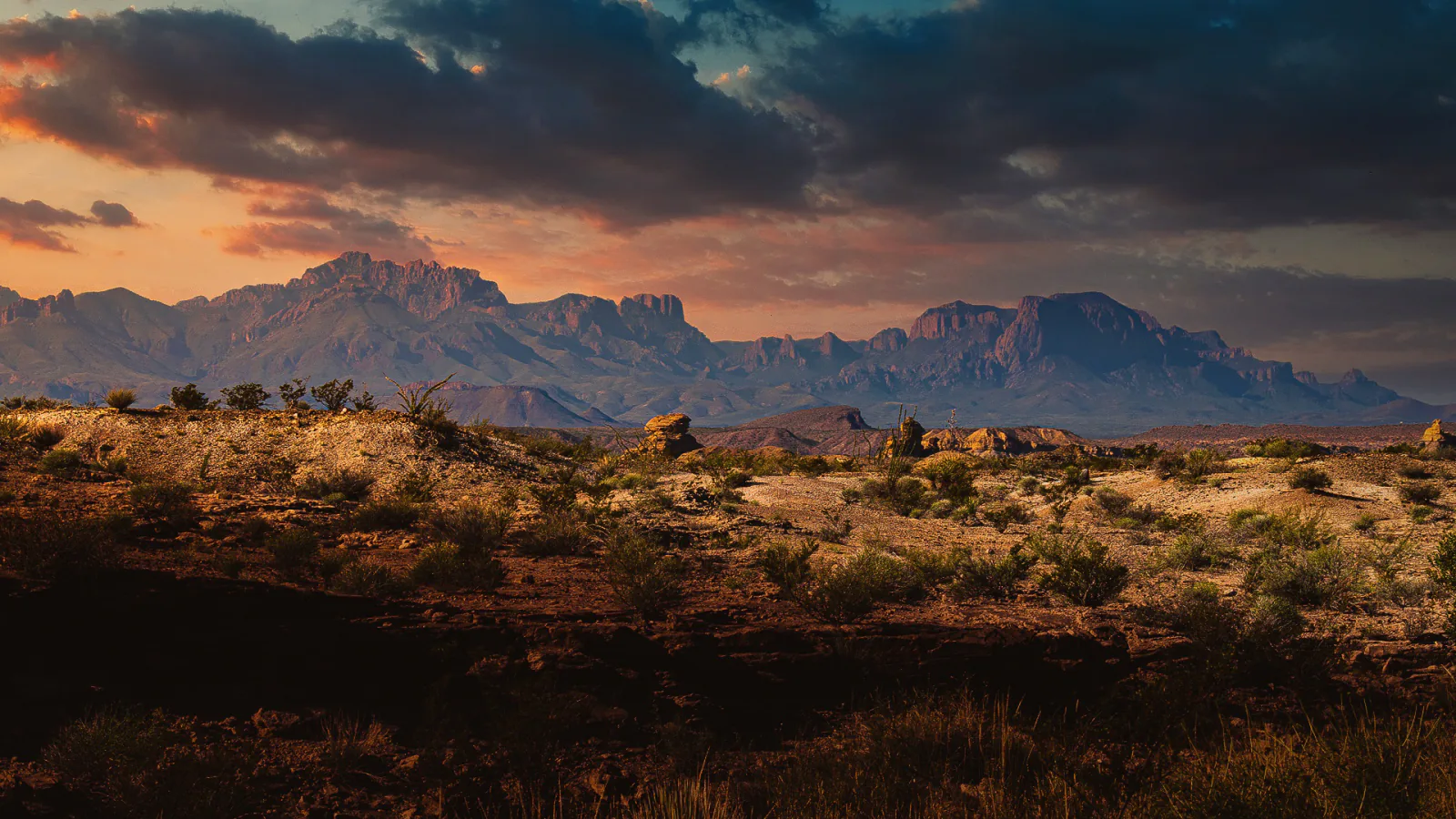
Big Bend is too large for a useful trail list that ignores the drive. A morning in the Chisos Mountains, an exposed walk from Ross Maxwell Scenic Drive, and an outing beside the Rio Grande can sit more than an hour apart. These ten hikes are arranged around those real planning decisions rather than a popularity ranking.
The High Chisos routes overlap because the trail network does. Lost Mine is the compact mountain viewpoint; Laguna Meadow is a quieter climb without a summit; the Emory Peak loop adds the park high point; South Rim spends its mileage reaching a long escarpment. Pick one of the longer objectives for a day instead of stacking similar mileage for the sake of a checklist.
Distances and elevation figures come from the reviewed route files shown below. Current access can change faster than an article: flash floods close primitive roads, summer heat removes low-elevation hikes from the sensible list, and seasonal wildlife protection can alter the East Rim. Read the live park alerts before leaving pavement or cell service.
What changes a hiking day here
The trailhead can decide the hike
Lost Mine has a small roadside lot with no overflow parking. Ernst Tinaja requires Old Ore Road, a rugged high-clearance four-wheel-drive route that is currently closed after flash-flood damage. Chisos Basin, Ross Maxwell Scenic Drive, and the Hot Springs district are separate destinations; build the day around one area instead of crossing the park repeatedly.
Desert mileage is seasonal
The desert floor is commonly above 100°F by late morning in summer, while the Chisos can be 10–15 degrees cooler. NPS recommends early starts and about one gallon of water per person on longer hikes. There are no reliable backcountry water sources, including springs that appear on a map.
The Basin closure was cancelled
A planned 2026 Chisos Basin construction closure did not proceed, and the park reports the Basin open. Older planning pages and downloaded visitor guides may still describe the cancelled closure. Treat the current conditions page as authoritative when the two disagree.
Pets stop where trails begin
Pets are not allowed on Big Bend trails or in the backcountry. They may be in places vehicles can go, but cannot be left unattended, and a parked car becomes lethal quickly in desert heat. Download maps before arrival; service is limited across much of the park.
| Trail | Distance | Time | Difficulty | Best for |
|---|---|---|---|---|
| Basin Loop Trail | 1.9 mi | 1 hr | Moderate | A short introduction to the Chisos Basin |
| Lost Mine Trail | 4.8 mi | 2 hr 34 min | Moderate | A half-day Chisos ridge view |
| The Window Trail | 5.6mi | 3 hr 27 min | Moderate | A canyon descent to Big Bend's signature pour-off |
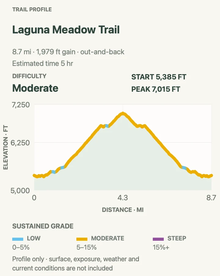
| Laguna Meadow Trail | 8.8 mi | 5 hr | Moderate | A long mountain climb without a summit scramble |
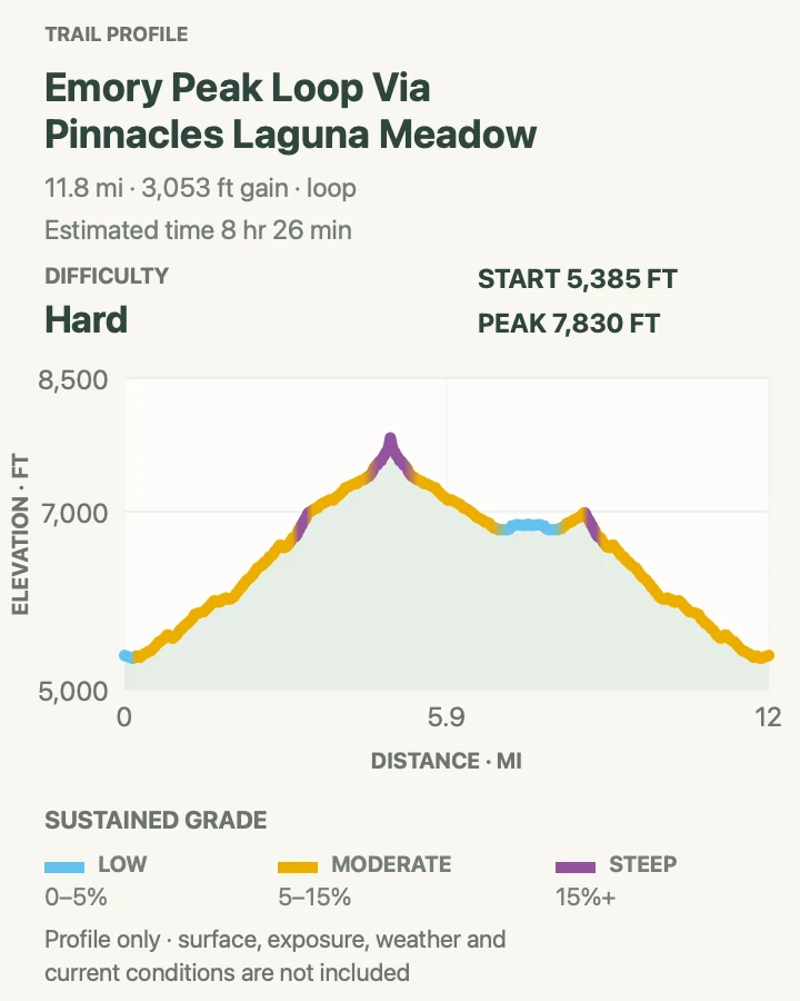
| Emory Peak via Pinnacles and Laguna Meadow | 11.9 mi | 8 hr 26 min | Hard | The park high point and a full High Chisos circuit |
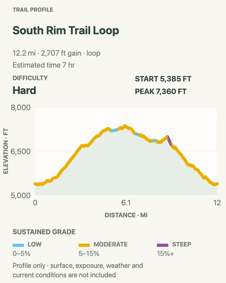
| South Rim Trail Loop | 12.3 mi | 7 hr | Hard | A long rim walk above the Chihuahuan Desert |
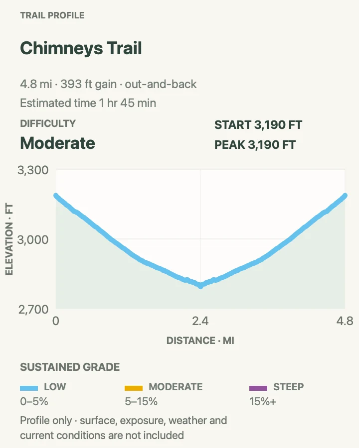
| Chimneys Trail | 4.8 mi | 1 hr 45 min | Moderate | Open-desert walking to volcanic formations and rock art |
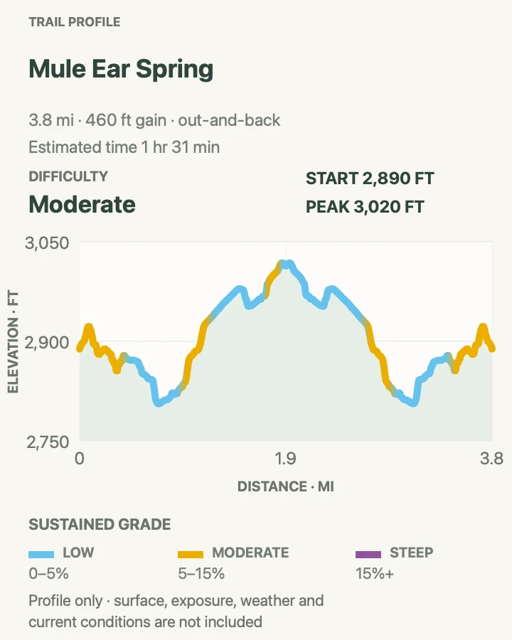
| Mule Ears Spring Trail | 3.8 mi | 1 hr 31 min | Moderate | Desert foothills and a small spring habitat |
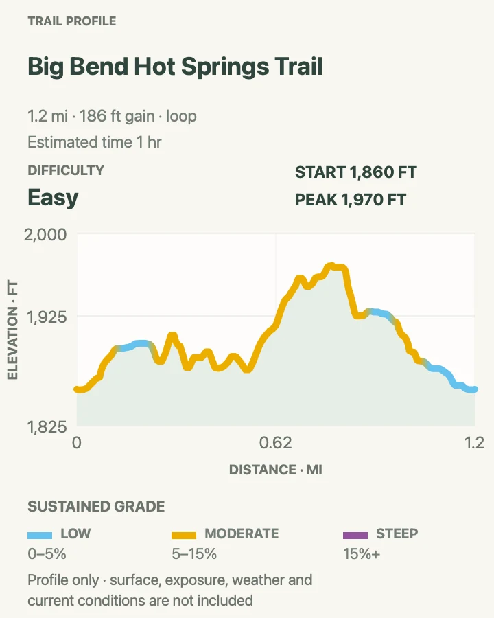
| Hot Springs Historic Trail | 1.2 mi | 1 hr | Easy | Rio Grande scenery, historic buildings, fossils, and a short walk |
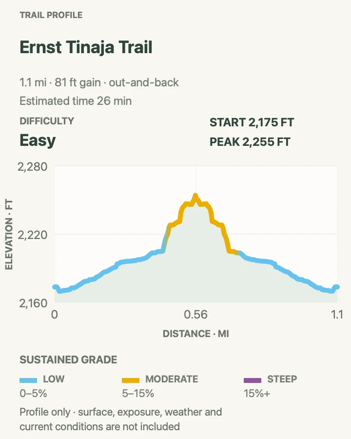
| Ernst Tinaja Trail | 1.1 mi | 26 min | Easy | A short limestone-canyon walk when primitive-road access is genuinely available |
Basin Loop Trail
- Distance
- 1.9 mi
- Elevation gain
- 400 feet
- Time
- 1 hr
- Difficulty
- Moderate
- Route type
- loop
- Parking
- Use the Chisos Basin trailhead parking area near the visitor center; arrive early when the campground and lodge are busy.
- Best time
- Morning or late afternoon in any season without ice, lightning, or extreme heat.
- Pets
- Pets are not allowed on park trails. Trained service animals are allowed.
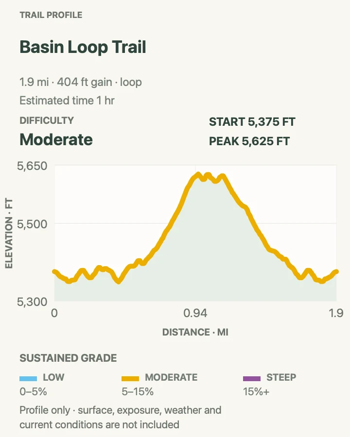
Basin Loop circles through piñon, juniper, sotol, and open slopes beneath Casa Grande and the Basin rim. Several junctions connect it with the Window and High Chisos trails, so the map matters despite the modest mileage.
The loop is a useful first walk after the long drive into Big Bend. It gains enough height to show the Basin's bowl shape without committing the day to Lost Mine or South Rim. Loose stone and short steeper pitches keep it from feeling like a paved nature path.
What helps on this route
- Check the junction signs carefully; multiple longer routes leave the same trailhead system.
- Use it as a temperature check before choosing a longer Chisos hike the next morning.
Terrain and access: Rocky dirt path, short climbs, mixed sun and woodland shade, signed junctions, and uneven steps.

Lost Mine Trail
- Distance
- 4.8 mi
- Elevation gain
- 1,180 feet
- Time
- 2 hr 34 min
- Difficulty
- Moderate
- Route type
- out-and-back
- Parking
- Use the small signed lot about 5 miles up Chisos Basin Road. Parking is limited and roadside overflow is not a dependable plan.
- Best time
- Sunrise or early morning, before the lot fills and exposed upper slopes warm.
- Pets
- Pets are not allowed on park trails. Trained service animals are allowed.
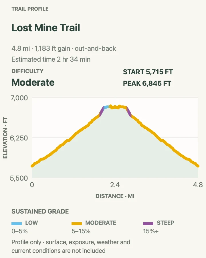
Lost Mine climbs through oak, juniper, and pine to a broad ridge above Pine Canyon. The first saddle, roughly a mile from the trailhead, already opens views toward Casa Grande and Juniper Canyon; it is a sensible turnaround when time or weather closes in.
Beyond the saddle, steeper switchbacks reach the ridge and its open rock slabs. The route ends on a viewpoint, not the summit of Lost Mine Peak. Afternoon thunder, slick rock, and a crowded return can change the character of an otherwise straightforward mountain trail.
What helps on this route
- Have a second Chisos plan ready if the parking lot is full.
- Do not wait on the exposed ridge when thunder is building over the mountains.
Terrain and access: Rocky switchbacks, pine-oak woodland, exposed ridge slabs, limited rail protection, and sustained climbing.

The Window Trail
- Distance
- 5.6mi
- Elevation gain
- 980 feet
- Time
- 3 hr 27 min
- Difficulty
- Moderate
- Route type
- loop
- Parking
- Begin at the Chisos Basin Campground trailhead for the shorter version; the lodge-area start adds distance and elevation.
- Best time
- Early morning, or late afternoon with enough daylight for the uphill return.
- Pets
- Pets are not allowed on park trails. Trained service animals are allowed.
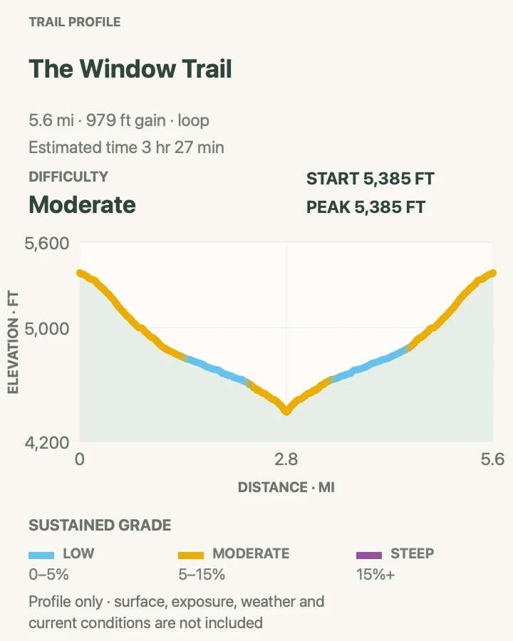
The Window Trail descends from the Basin through open grassland into the shade of Oak Creek Canyon. Polished rock funnels toward the pour-off, where the desert appears through a narrow gap in the Chisos wall.
The elevation profile is easy to misread because the outward leg goes downhill. Save water and energy for the climb back. The final slickrock is smooth, has no railing, and can carry water after rain; stop well short of the drop.
What helps on this route
- Remember which of the two upper trailheads you used before returning through the junction.
- Keep away from the lip even when the rock is dry; the pour-off edge is exposed.
Terrain and access: Descending dirt trail, creek crossings, shaded canyon, rock steps, polished slickrock, and an uphill return.

Laguna Meadow Trail
- Distance
- 8.8 mi
- Elevation gain
- 1,980 feet
- Time
- 5 hr
- Difficulty
- Moderate
- Route type
- out-and-back
- Parking
- Start at the main Chisos Basin trailhead and use the Laguna Meadow branch rather than Pinnacles.
- Best time
- A cool morning in spring or fall; winter snow and summer storms can alter the upper trail.
- Pets
- Pets are not allowed on park trails. Trained service animals are allowed.
Laguna Meadow gains the High Chisos on longer, more gradual turns than Pinnacles. Open views back into the Basin alternate with wooded sections, and the upper trail reaches the meadow-and-saddle country used by South Rim circuits.
This out-and-back stops short of the rim and Emory Peak. That makes it a legitimate destination for hikers who want sustained mountain mileage without adding an exposed summit or a twelve-mile loop. Bear and mountain-lion habitat begins close to the developed Basin, so keep children nearby and food secured.
What helps on this route
- Set a turnaround time because the easy-looking descent can disguise how far the climb has gone.
- Carry all water; mapped springs are not dependable drinking sources.
Terrain and access: Long graded switchbacks, rocky tread, oak-juniper woodland, exposed meadow sections, and sustained elevation gain.

Emory Peak via Pinnacles and Laguna Meadow
- Distance
- 11.9 mi
- Elevation gain
- 3,050 feet
- Time
- 8 hr 26 min
- Difficulty
- Hard
- Route type
- loop
- Parking
- Use the main Chisos Basin trailhead and follow Pinnacles uphill; return by Laguna Meadow to make the loop.
- Best time
- A cool, dry day with an early start and no thunder forecast.
- Pets
- Pets are not allowed on park trails. Trained service animals are allowed.
This circuit climbs steeply on Pinnacles, takes the Emory Peak spur, and returns by the broader Laguna Meadow trail. The loop shape gives the day more variety than repeating the Pinnacles climb in reverse, while still requiring nearly twelve miles at elevation.
The final quarter mile steepens, and the last approach to the 7,832-foot summit includes an exposed rock scramble. The antennas are park radio equipment. Anyone uneasy with the final moves can stop below the summit and still complete the mountain circuit.
What helps on this route
- Finish the summit spur before clouds build; the upper rocks are a poor place to wait out lightning.
- Carry a headlamp even on a day hike because route time expands quickly with a slow summit party.
Terrain and access: Steep switchbacks, wooded high country, rocky summit spur, exposed final scramble, and a long gradual descent.

South Rim Trail Loop
- Distance
- 12.3 mi
- Elevation gain
- 2,710 feet
- Time
- 7 hr
- Difficulty
- Hard
- Route type
- loop
- Parking
- Begin at the Chisos Basin trailhead; choose Pinnacles or Laguna Meadow for the ascent and return on the other branch.
- Best time
- A clear cool-season day, or a summer day with a dawn start and a stable mountain forecast.
- Pets
- Pets are not allowed on park trails. Trained service animals are allowed.
South Rim trades a summit for miles along the Chisos escarpment. The route climbs roughly two thousand feet from the Basin before reaching open viewpoints over the desert and ranges extending into Mexico.
A standard seasonal closure can affect the East Rim segment and campsites from February 1 through May 31, although monitoring kept that section open in spring 2026. Check the current closure map rather than assuming the annual pattern. This is a full-day route with no dependable water.
What helps on this route
- Choose the western South Rim option when the East Rim is closed; do not cross a posted wildlife closure.
- Turn back before fatigue removes the margin needed for the long descent to the Basin.
Terrain and access: Sustained mountain climbing, wooded canyons, exposed rim travel, rocky trail, steep drop-offs, and a long descent.

Chimneys Trail
- Distance
- 4.8 mi
- Elevation gain
- 390 feet
- Time
- 1 hr 45 min
- Difficulty
- Moderate
- Route type
- out-and-back
- Parking
- Use the signed pullout at mile 13 on Ross Maxwell Scenic Drive; do not block the road shoulder.
- Best time
- November through March, or at first light on an unusually cool shoulder-season day.
- Pets
- Pets are not allowed on park trails. Trained service animals are allowed.
Chimneys crosses exposed desert flats to a line of volcanic dikes visible from the trailhead. At their base are rock shelters and Indigenous pictographs and petroglyphs. These are protected cultural places, not surfaces to touch, trace, wet, or climb.
Navigation is visually simple in clear weather, yet the lack of shade makes four to five miles consequential. The maintained day-hike turnaround is at the Chimneys; a longer continuation reaches Old Maverick Road only when a separate vehicle shuttle has been arranged.
What helps on this route
- Photograph rock art without touching it or sharing precise off-trail locations.
- Carry more water than a similar-distance mountain walk and abandon the route in dangerous heat.
Terrain and access: Nearly treeless desert tread, gravel and rock, shallow arroyos, full sun, and minor route-finding near the formations.

Mule Ears Spring Trail
- Distance
- 3.8 mi
- Elevation gain
- 460 feet
- Time
- 1 hr 31 min
- Difficulty
- Moderate
- Route type
- out-and-back
- Parking
- Park at Mule Ears Overlook, mile 15 on Ross Maxwell Scenic Drive.
- Best time
- Late fall through early spring, beginning early enough to avoid midday heat.
- Pets
- Pets are not allowed on park trails. Trained service animals are allowed.
Mule Ears Spring heads across the Chisos foothills, skirts Trap Mountain, and crosses several arroyos on the way to an old rock corral and a brushy spring. The twin Mule Ears peaks remain a useful orientation point through much of the walk.
The spring supports ferns and cattails but is neither a swimming stop nor a reliable refill. Keep soap, food, and feet out of the water, and carry the full supply needed for the return. The route's repeated dips account for more gain than the broad desert view suggests.
What helps on this route
- Treat the spring as habitat, not drinking water or a place to cool off.
- Watch the return junctions where multiple washes look more prominent than the tread.
Terrain and access: Open desert path, loose rock, repeated arroyo crossings, low rolling climbs, sparse shade, and a brushy spring approach.

Hot Springs Historic Trail
- Distance
- 1.2 mi
- Elevation gain
- 190 feet
- Time
- 1 hr
- Difficulty
- Easy
- Route type
- loop
- Parking
- Use the Hot Springs Historic District parking area when Hot Springs Road is open; oversized vehicles cannot negotiate the final narrow road.
- Best time
- A cool morning outside periods of high river flow or extreme heat.
- Pets
- Pets are not allowed on park trails. Trained service animals are allowed.
This compact loop links the former post office and bathhouse area with limestone ledges beside the Rio Grande. Pictographs, historic structures, and a large fossil ammonite sit along the corridor; every one of them must remain untouched.
The 105°F spring water reaches the river beside the old bathhouse foundation. River currents, sudden depth changes, microorganisms, and rising water remain hazards even when the bank looks calm. Glass and alcohol are prohibited in the Hot Springs area.
What helps on this route
- Protect the historic fabric by staying off walls and leaving fossils and pictographs as found.
- Skip the water when the river is high, conditions are posted unsafe, or the heat makes the return unwise.
Terrain and access: Sand and rock, short ledges, exposed riverbank, historic ruins, minimal shade, and possible high-water restrictions.

Ernst Tinaja Trail
- Distance
- 1.1 mi
- Elevation gain
- 80 feet
- Time
- 26 min
- Difficulty
- Easy
- Route type
- out-and-back
- Parking
- Reach the tiny trailhead only from the southern end of Old Ore Road with a rugged high-clearance four-wheel-drive vehicle. Old Ore Road is currently closed after flood damage, so this hike is not presently accessible.
- Best time
- Only after Old Ore Road reopens, on a cool dry morning with no flash-flood risk.
- Pets
- Pets are not allowed on park trails. Trained service animals are allowed.
Ernst Tinaja enters a narrow limestone canyon striped with folded orange rock and giant fossil oysters. The namesake tinaja is a deep natural pool scoured into the creek bed about half a mile from the road.
Road access is the controlling fact. NPS describes Old Ore as extremely rocky even when open, and current alerts list it closed after flash flooding. Do not route around a gate or substitute an ordinary passenger car. At the pool, smooth walls and deep water can trap wildlife and people; keep back from the rim.
What helps on this route
- Confirm Old Ore Road has reopened with NPS on the day of travel; the live alert above takes precedence over this entry.
- Do not enter the tinaja or approach wet polished ledges.
Terrain and access: Primitive-road approach, deep sand, limestone bedrock, short boulder steps, narrow canyon, and an unprotected water hole.

Official planning sources
Trail access and safety details were checked against these National Park Service pages. The maps and profiles use the reviewed route geometry stored with this guide.
Map data © OpenStreetMap contributors. Trail geometry and planning details include National Park Service public information.