9 Best Hikes in Grand Teton National Park
Nine Grand Teton hikes from Colter Bay to Paintbrush Divide, with reviewed maps, elevation profiles, current access notes, and live NPS alerts.
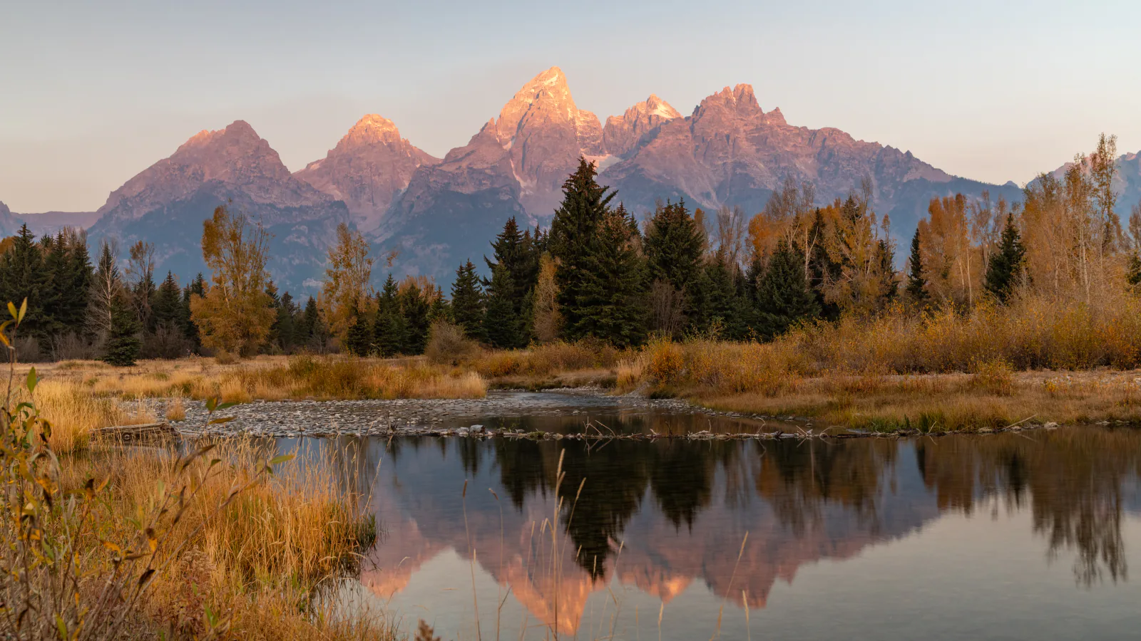
Grand Teton hiking days are shaped by where the trail begins. Colter Bay sits far north of Jenny Lake, Lupine Meadows serves the steep lake basins, and the String Lake trailhead opens a different set of shore and canyon routes. These nine hikes are arranged around those practical differences rather than copied from a popularity ranking.
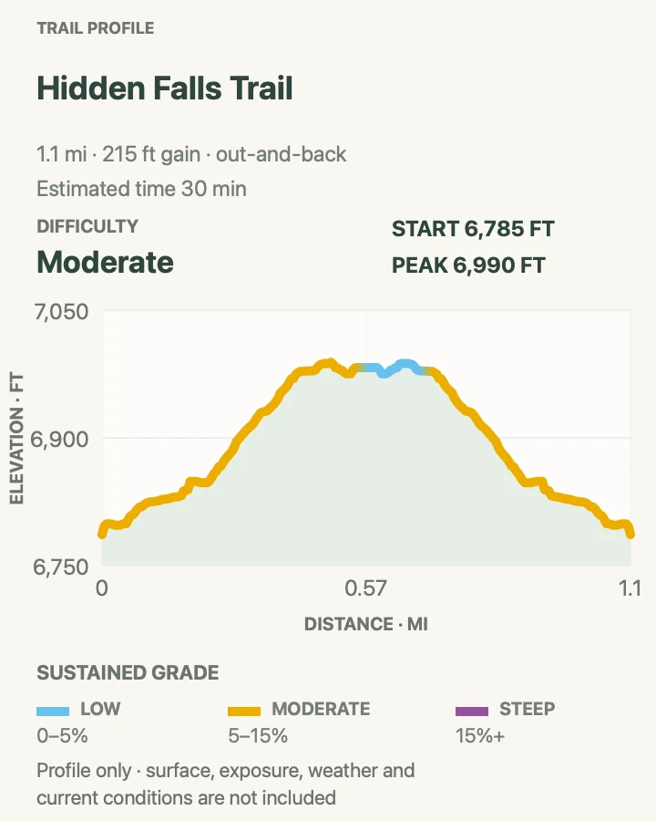
A traveler can take a quiet Jackson Lake loop, use the Jenny Lake boat for a short waterfall walk, circle two foothill lakes, or spend a demanding day above 9,000 feet. Hidden Falls and Inspiration Point share an approach; both appear because the falls is a sensible family turnaround while the overlook is a separate choice for hikers willing to climb farther.
Distances and elevation gain come from the route line behind each profile. The maps are planning aids, not a substitute for the current NPS trail report. Snow, construction, bears, fire, boat operations, and crowded parking can all change the day, so read the live alert panel and the official conditions page before leaving the trailhead.
What changes a hiking day here
The 2026 Taggart closure changes the loop
The north side of Taggart Trail is closed during reconstruction in 2026. Taggart Trailhead and the south approach remain open, but the mapped Taggart–Bradley loop may not be walkable as drawn while that closure is active. Check the park's hiking page and use the signed open route on the day of the hike.
Jenny Lake mileage depends on the boat
From the visitor center, the NPS lists Hidden Falls at about 5 miles round trip and Inspiration Point at about 6 miles. From the west boat dock, those trips shrink to roughly 1 and 2 miles. The shuttle boat charges a fee and operates seasonally; verify its schedule and leave enough time to hike around the lake if the last return boat is missed.
Carry bear spray on every trail
Black and grizzly bears use every district in the park, including developed lake areas. The NPS advises hiking in groups of three or more, making noise, and carrying bear spray where it can be reached. Stay 100 yards from bears and wolves and 25 yards from other wildlife.
High routes keep winter longer
Valley trails may clear by mid-June while mountain passes hold snow into late July or beyond. Paintbrush Divide, Amphitheater Lake, and Delta Lake need a fresh conditions check, an early start, and a weather plan. Turn around when steep snow, lightning, smoke, or route finding exceeds the group's experience.
| Trail | Distance | Time | Difficulty | Best for |
|---|---|---|---|---|
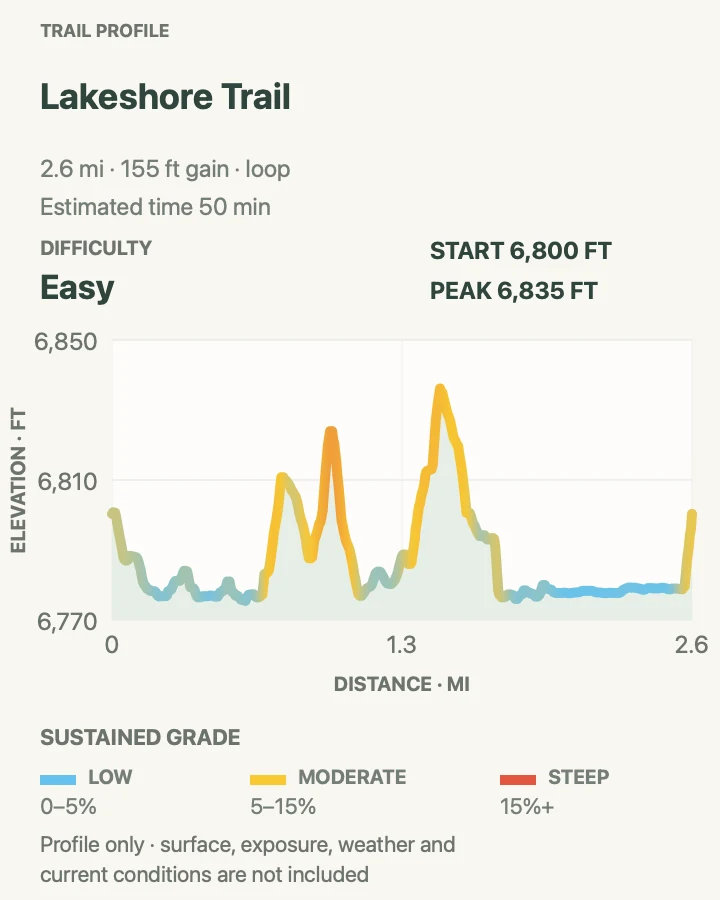
| Lakeshore Trail at Colter Bay | 2.6 mi | 50 min | Easy | An easy Jackson Lake walk with Teton views |
| Hidden Falls from the West Boat Dock | 1.1 mi | 30 min | Moderate | A short family waterfall walk |
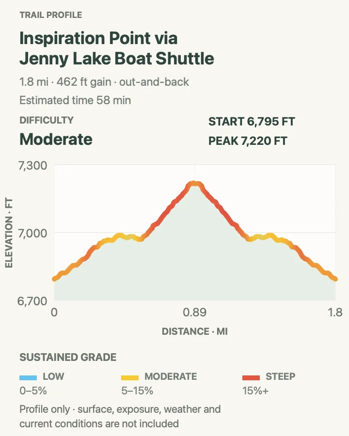
| Inspiration Point via the Jenny Lake Boat | 1.8 mi | 58 min | Moderate | The classic short Jenny Lake overlook |
| Jenny Lake Loop from String Lake | 7.7 mi | 3 hr 30 min | Moderate | A full circuit without relying on the boat |
| Leigh Lake Trail | 7.3 mi | 2 hr 30 min | Easy | A long, gentle lake day |
| Taggart Lake and Bradley Lake Loop | 5.8 mi | 2 hr 28 min | Moderate | Two foothill lakes in a half day |
| Surprise and Amphitheater Lakes Trail | 10.3 mi | 7 hr 39 min | Hard | A sustained climb to two alpine lakes |
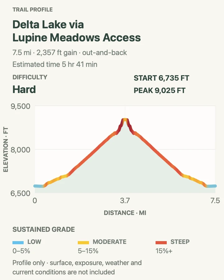
| Delta Lake via Lupine Meadows | 7.6 mi | 5 hr 41 min | Hard | Experienced hikers comfortable on an unofficial route |
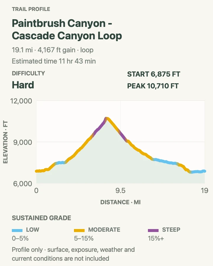
| Paintbrush Canyon–Cascade Canyon Loop | 19.3 mi | 11 hr 43 min | Strenuous | A major alpine circuit for strong, prepared hikers |
Lakeshore Trail at Colter Bay
- Distance
- 2.6 mi
- Elevation gain
- 160 feet
- Time
- 50 min
- Difficulty
- Easy
- Route type
- loop
- Parking
- Use the main Colter Bay visitor area and begin beside the marina; follow posted day-use parking signs.
- Best time
- Morning for calm Jackson Lake water, or late afternoon after the busiest visitor-center hours.
- Pets
- Pets are not allowed on park trails. Trained service animals are allowed.
Colter Bay's Lakeshore Trail traces two wooded peninsulas beside Jackson Lake. Short connectors make the route look busier on a map than it feels on foot: the outing is a string of beaches, forest corners, marina views, and open water.
This is the useful easy hike at the north end of the park. It pairs naturally with a Colter Bay morning and avoids a drive toward Jenny Lake. Roots and small shoreline rises account for most of the effort, while wind can change a placid beach into a cold, choppy edge within minutes.
What helps on this route
- Take the signed peninsula loops rather than wandering onto marina service paths.
- Bring a wind layer even when the Colter Bay parking area feels warm.
Terrain and access: Mostly gentle forest and shoreline tread with roots, short rises, sand or gravel, and unguarded water edges.


Inspiration Point via the Jenny Lake Boat
- Distance
- 1.8 mi
- Elevation gain
- 460 feet
- Time
- 58 min
- Difficulty
- Moderate
- Route type
- out-and-back
- Parking
- Use Jenny Lake parking and the paid seasonal shuttle to the west dock; without the boat, budget for the longer shore approach.
- Best time
- Early morning, when boat queues are shorter and the exposed overlook is cooler.
- Pets
- Pets are not allowed on park trails. Trained service animals are allowed.
Inspiration Point extends the Hidden Falls outing uphill through switchbacks and rocky ledges. The reward is an open perch above Jenny Lake with the glacial valley spread east toward Jackson Hole. Narrow passages and two-way traffic slow the upper section.
The profile shown here corresponds to the boat-assisted route. Hikers who walk from the visitor center will cover much more ground than the displayed 1.8 miles. Keep an eye on children at the exposed viewpoint, and step aside only where the tread is wide and durable.
What helps on this route
- Treat the mapped distance as boat-dock to overlook, not visitor-center mileage.
- Descend before a building boat queue threatens the final crossing of the day.
Terrain and access: Shaded creek trail followed by stone steps, switchbacks, rocky ledges, and an exposed overlook.

Jenny Lake Loop from String Lake
- Distance
- 7.7 mi
- Elevation gain
- 890 feet
- Time
- 3 hr 30 min
- Difficulty
- Moderate
- Route type
- loop
- Parking
- Use the String Lake trailhead; arrive early because the lot also serves Leigh Lake and canyon hikers.
- Best time
- A cool morning or a clear shoulder-season day after the shore trail is snow-free.
- Pets
- Pets are not allowed on park trails. Trained service animals are allowed.
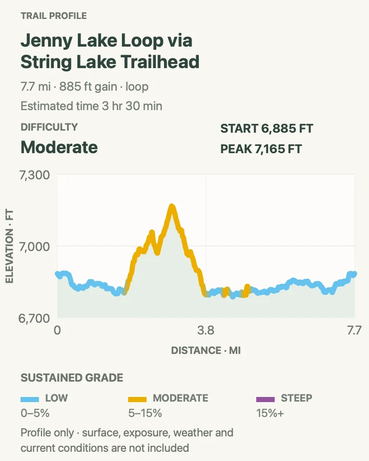
Starting at String Lake turns the Jenny Lake circuit into a self-contained loop. The west shore runs beneath the peaks and passes the busy Hidden Falls corridor; the east side opens toward the valley and returns through quieter forest and lake edges.
Seven-plus miles of rolling shore trail feel longer than the modest elevation gain suggests. Numerous junctions serve docks, overlooks, horse routes, and shorter walks. Save the loop before setting out, then follow current closure signs when a construction or wildlife detour changes the familiar line.
What helps on this route
- Carry enough water for the entire circuit rather than counting on developed facilities mid-hike.
- Move through the Hidden Falls junction patiently; it is the busiest part of the loop.
Terrain and access: Rolling lakeshore trail with roots, rock, bridges, several junctions, and short climbs above Jenny Lake.

Leigh Lake Trail
- Distance
- 7.3 mi
- Elevation gain
- 100 feet
- Time
- 2 hr 30 min
- Difficulty
- Easy
- Route type
- out-and-back
- Parking
- Start at the String Lake or Leigh Lake trailhead and use only designated spaces.
- Best time
- Early morning for quiet water and a better chance of parking at String Lake.
- Pets
- Pets are not allowed on park trails. Trained service animals are allowed.
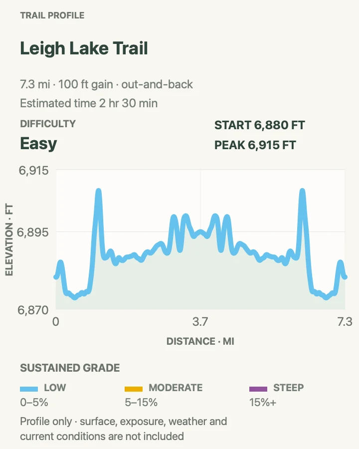
Leigh Lake Trail follows the eastern shores of String and Leigh lakes with the Tetons rising directly across the water. Distance builds gradually, while the grade stays mild enough for hikers who prefer mileage over climbing.
There is no single dramatic summit moment. Beaches, forest openings, and shifting views carry the day. The out-and-back format also makes the length adjustable: choose a firm turnaround time, since every extra shoreline mile must be retraced.
What helps on this route
- Make noise in the dense shore vegetation, especially near blind bends.
- Do not let a quiet beach tempt the group past its planned return time.
Terrain and access: Gentle forest and lakeshore tread with roots, occasional wet patches, beaches, and very little sustained climbing.

Taggart Lake and Bradley Lake Loop
- Distance
- 5.8 mi
- Elevation gain
- 890 feet
- Time
- 2 hr 28 min
- Difficulty
- Moderate
- Route type
- loop
- Parking
- Use Taggart Lake Trailhead; parking fills early and the north side of Taggart Trail is closed during 2026 reconstruction.
- Best time
- Early morning, after confirming which signed approach and connectors are open.
- Pets
- Pets are not allowed on park trails. Trained service animals are allowed.
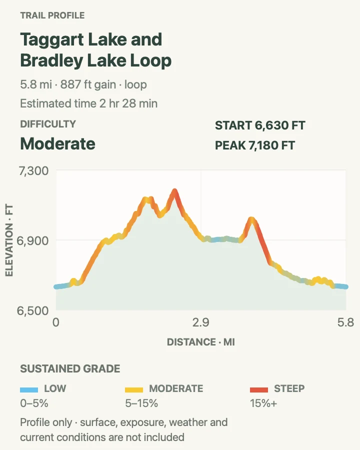
Taggart and Bradley lakes sit close to the trailhead yet deliver an abrupt change from sagebrush flats to moraine forest and mountain water. Linking both makes a varied half-day route with repeated views toward the central Teton skyline.
The 2026 north-side closure means the saved loop can conflict with what is open on the ground. Do not cross a closure to preserve the mapped shape. Use the south side and any ranger-signed legal variation, accepting that the distance may differ until reconstruction finishes.
What helps on this route
- Read the closure board at the trailhead before choosing a junction.
- Add Bradley Lake only when time, weather, and the current open route all support it.
Terrain and access: Rolling moraine trail, forest roots, short steeper climbs between lakes, and exposed sage near the trailhead.

Surprise and Amphitheater Lakes Trail
- Distance
- 10.3 mi
- Elevation gain
- 2,990 feet
- Time
- 7 hr 39 min
- Difficulty
- Hard
- Route type
- out-and-back
- Parking
- Begin at Lupine Meadows; use the current parking guidance and expect the lot to fill on clear summer mornings.
- Best time
- A dawn start after snow has cleared from the upper basins and the forecast is stable.
- Pets
- Pets are not allowed on park trails. Trained service animals are allowed.
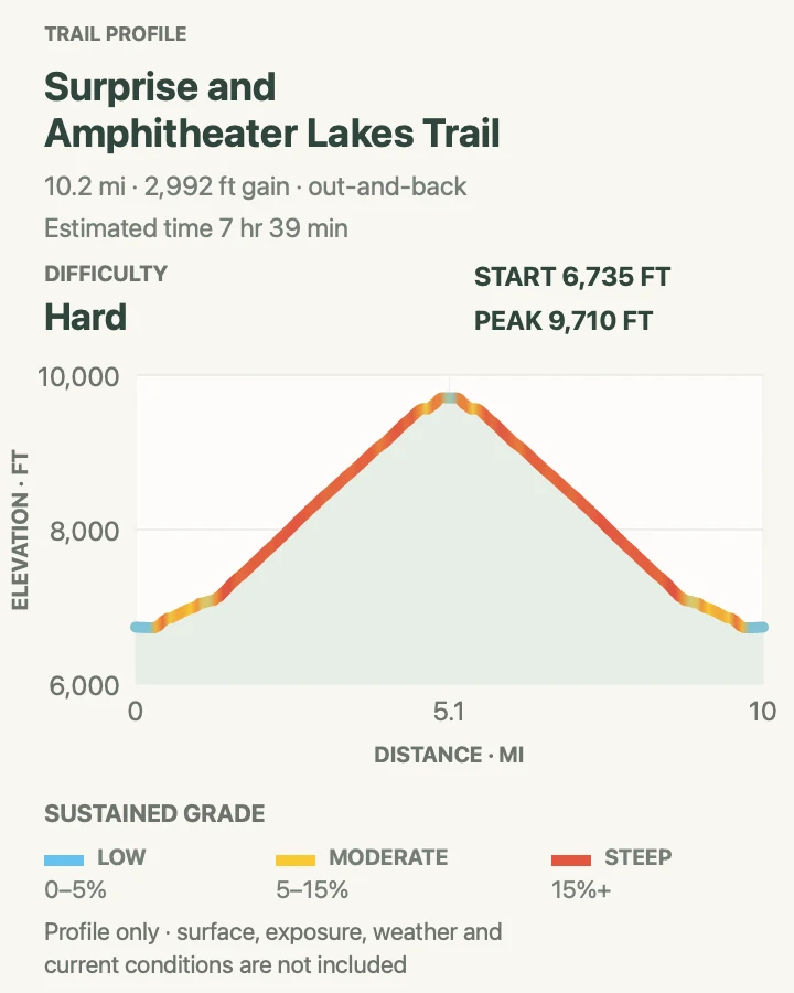
This Lupine Meadows trail climbs nearly 3,000 feet to Surprise Lake and Amphitheater Lake beneath Disappointment Peak. Long switchbacks create a steady rhythm, and the upper basin feels markedly colder and rougher than the valley floor.
Ten miles is only part of the workload. Sun exposure, altitude, and the long descent all add strain. Snow may remain in the basins after the lower trail is dry, so the current trail report should decide what equipment belongs in the pack and when to turn around.
What helps on this route
- Carry more water than a shaded trailhead might suggest and treat natural water before drinking.
- Save energy for the descent; tired feet make loose corners less forgiving.
Terrain and access: Sustained switchbacks, forest and open slopes, rocky upper basins, possible snow, and nearly 3,000 feet of gain.

Delta Lake via Lupine Meadows
- Distance
- 7.6 mi
- Elevation gain
- 2,360 feet
- Time
- 5 hr 41 min
- Difficulty
- Hard
- Route type
- out-and-back
- Parking
- Start at Lupine Meadows and follow the official trail toward Garnet Canyon before the unsigned Delta Lake route branches away.
- Best time
- Early on a dry, stable day after the latest route and work-zone report has been checked.
- Pets
- Pets are not allowed on park trails. Trained service animals are allowed.
Delta Lake occupies a steep basin below the Grand Teton, reached from Lupine Meadows by maintained trail and a rough final approach. The last section crosses boulders and eroded ground where navigation and footing demand more attention than the mileage implies.
The NPS describes Delta Lake as an unofficial, heavily traveled route. Improvement work in 2026 addresses erosion and visitor safety, so temporary delays or work zones are possible. This is a poor choice for anyone expecting continuous signs, engineered tread, or an easy retreat during a storm.
What helps on this route
- Download the route and current NPS conditions before leaving service, then keep the map available offline.
- Give crews room and stay on the stabilized line through any active work zone.
Terrain and access: Maintained approach followed by steep switchbacks, loose rock, boulders, route finding, and grades above 15 percent.

Paintbrush Canyon–Cascade Canyon Loop
- Distance
- 19.3 mi
- Elevation gain
- 4,170 feet
- Time
- 11 hr 43 min
- Difficulty
- Strenuous
- Route type
- loop
- Parking
- Use String Lake parking and begin early enough to finish the full circuit in daylight.
- Best time
- A long midsummer or early-fall day when Paintbrush Divide is free of hazardous snow and storms are unlikely.
- Pets
- Pets are not allowed on park trails. Trained service animals are allowed.
Paintbrush Canyon and Cascade Canyon form the park's defining long day loop. The route climbs past Holly Lake to 10,700-foot Paintbrush Divide, crosses stark alpine ground, then descends through Lake Solitude and the length of Cascade Canyon.
Nineteen miles and almost twelve estimated hours leave little room for a casual start. Snow on Paintbrush Divide can require an ice axe, traction, and the skill to use them; a clear valley forecast does not erase high-pass conditions. Many hikers split this terrain into a backpacking trip, which requires the appropriate permit.
What helps on this route
- Check the Paintbrush Divide report itself, not a general valley weather forecast.
- Turn around early if pace, snow, smoke, or thunder threatens a daylight finish.
Terrain and access: Long canyon trail, sustained climbing, talus, an exposed 10,700-foot divide, possible steep snow, and a long descent.

Official planning sources
Trail access and safety details were checked against these National Park Service pages. The maps and profiles use the reviewed route geometry stored with this guide.
Map data © OpenStreetMap contributors. Trail geometry and planning details include National Park Service public information.